Miura geodata
Miura (Kanagawa) is a seat of a second-order administrative division; located in Japan in Asia/Tokyo (GMT+9) time zone. With population of 51,483 people, there are 368 cities with bigger population in this country. Compared to other cities in Japan, 55.3% of cities are located further ↑North; 71.9% of cities are located further ←West and 79% of cities have higher elevation than Miura. Note1


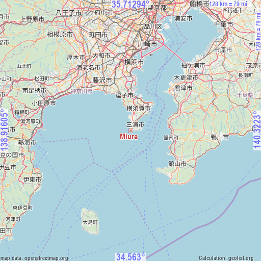
Miura GPS coordinates[2]
35° 8' 24" North, 139° 37' 9.012" East
| Map corner | latitude | longitude |
|---|---|---|
| Upper-left | 35.71294°, | 138.91605° |
| Center: | 35.14°, | 139.61917° |
| Lower-right: | 34.563°, | 140.3223° |
| Map W x H: | 127.9×127.9 km | = 79.5×79.5mi |
| max Lat: | 45.40944° ⇑55.3% North |
| Miura: | 35.14° |
| min Lat: | ⇓44.7% South 24.34478° |
| min Long | Miura | max Long |
| 123° | 139.61917° | 145.575° |
| W 71.9%⇐ | ⇒28.1% E |
Elevation
Elevation of Miura is 8 m = 26 ft, and this is 76.6 m = 251 ft below average elevation for this country.
| Max E: |
1086 m = 3563 ft | 79% |
| Avg. | 84.6 m = 278 ft | |
| Miura | 8 m = 26 ft | |
Min E: |
-2 m = -7 ft | 21% |
See also: Miura elevation on elevation.city.
Geographical zone
Miura is located in North temperate zone (between Tropic of Cancer and the Arctic Circle). Distance of this Northern Tropic circle is 1301.3 km =808.6 mi to South.| Distance of | km | miles | from Miura |
|---|---|---|---|
| North Pole | 6099.9 | 3790.3 | to North |
| Arctic Circle | 3494 | 2171.1 | to North |
| Tropic Cancer | 1301.3 | 808.6 | to South |
| Equator | 3907.2 | 2427.8 | to South |


Nearby cities:
15 places around Miura: (largest is in red/bold)
• Ayase
37.2 km =23.1 mi,  331°
331°
• Chigasaki
29.3 km =18.2 mi,  318°
318°
• Fujisawa
26.6 km =16.5 mi, 330°
• Futtsu
26.3 km =16.3 mi,  43°
43°
• Hayama
15.6 km =9.7 mi,  345°
345°
• Hiratsuka
33 km =20.5 mi,  309°
309°
• Kamakura
19.8 km =12.3 mi,  341°
341°
• Kimitsu
32.7 km =20.3 mi, 44°
• Minamibōsō
30.5 km =19 mi,  113°
113°
• Ninomiya
37.6 km =23.4 mi,  298°
298°
• Tateyama
28.5 km =17.7 mi,  127°
127°
• Yokohama
32.7 km =20.3 mi,  4°
4°
• Yokosuka
16.6 km =10.3 mi,  15°
15°
• Zushi
17.6 km =10.9 mi, 347°
• Ōiso
33.7 km =20.9 mi, 305°
Sources, notices
• [Note1] Compared only with cities in Japan existing in our database
• [Src1] Map data: © OpenStreetMap contributors (CC-BY-SA)
• [Src2] Other city data from geonames.org with taken over terms of usage.
• [Src3] Geographical zone / Annual Mean Temperature by Robert A. Rohde @ Wikipedia
