Ichihara geodata
Ichihara (Chiba) is a seat of a second-order administrative division; located in Japan in Asia/Tokyo (GMT+9) time zone. With population of 283,531 people, there are 71 cities with bigger population in this country. Compared to other cities in Japan, 53.8% of cities are located further ↓South; 79.9% of cities are located further ←West and 97.9% of cities have higher elevation than Ichihara. Note1


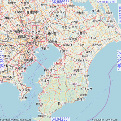
Ichihara GPS coordinates[2]
35° 31' 0.012" North, 140° 4' 59.988" East
| Map corner | latitude | longitude |
|---|---|---|
| Upper-left | 36.08693°, | 139.38021° |
| Center: | 35.51667°, | 140.08333° |
| Lower-right: | 34.94233°, | 140.78646° |
| Map W x H: | 127.3×127.3 km | = 79.1×79.1mi |
| max Lat: | 45.40944° ⇑46.2% North |
| Ichihara: | 35.51667° |
| min Lat: | ⇓53.8% South 24.34478° |
| min Long | Ichihara | max Long |
| 123° | 140.08333° | 145.575° |
| W 79.9%⇐ | ⇒20.1% E |
Elevation
Elevation of Ichihara is 1 m = 3 ft, and this is 83.6 m = 274 ft below average elevation for this country.
| Max E: |
1086 m = 3563 ft | 97.9% |
| Avg. | 84.6 m = 278 ft | |
| Ichihara | 1 m = 3 ft | |
Min E: |
-2 m = -7 ft | 2.1% |
See also: Ichihara elevation on elevation.city.
Geographical zone
Ichihara is located in North temperate zone (between Tropic of Cancer and the Arctic Circle). Distance of this Northern Tropic circle is 1343.2 km =834.6 mi to South.| Distance of | km | miles | from Ichihara |
|---|---|---|---|
| North Pole | 6058 | 3764.3 | to North |
| Arctic Circle | 3452.1 | 2145 | to North |
| Tropic Cancer | 1343.2 | 834.6 | to South |
| Equator | 3949.1 | 2453.9 | to South |


Nearby cities:
15 places around Ichihara: (largest is in red/bold)
• Chiba
9.7 km =6 mi,  18°
18°
• Funabashi
23.6 km =14.7 mi,  344°
344°
• Honchō
22.3 km =13.9 mi, 336°
• Kisarazu
20.2 km =12.6 mi,  222°
222°
• Mobara
21.8 km =13.5 mi,  117°
117°
• Narashino
18.8 km =11.7 mi,  348°
348°
• Sodegaura
12.8 km =8 mi,  206°
206°
• Tōgane
25.9 km =16.1 mi,  81°
81°
• Urayasu
21.4 km =13.3 mi,  310°
310°
• Urayasu
24.6 km =15.3 mi, 314°
• Yachimata
25.8 km =16 mi,  54°
54°
• Yachiyo
24.6 km =15.3 mi,  8°
8°
• Yotsukaidō
16.6 km =10.3 mi,  26°
26°
• Ōami
21.1 km =13.1 mi,  90°
90°
• Ōamishirasato
24.4 km =15.2 mi, 91°
Sources, notices
• [Note1] Compared only with cities in Japan existing in our database
• [Src1] Map data: © OpenStreetMap contributors (CC-BY-SA)
• [Src2] Other city data from geonames.org with taken over terms of usage.
• [Src3] Geographical zone / Annual Mean Temperature by Robert A. Rohde @ Wikipedia
