Ōhara geodata
Ōhara (Chiba) is a populated place; located in Japan in Asia/Tokyo (GMT+9) time zone. With population of 20,226 people, there are 690 cities with bigger population in this country. Compared to other cities in Japan, 53.3% of cities are located further ↑North; 84.8% of cities are located further ←West and 76.3% of cities have higher elevation than Ōhara. Note1


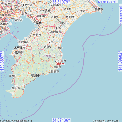
Ōhara GPS coordinates[2]
35° 14' 51.396" North, 140° 23' 34.404" East
| Map corner | latitude | longitude |
|---|---|---|
| Upper-left | 35.81979°, | 139.68977° |
| Center: | 35.24761°, | 140.39289° |
| Lower-right: | 34.67136°, | 141.09602° |
| Map W x H: | 127.7×127.7 km | = 79.3×79.3mi |
| max Lat: | 45.40944° ⇑53.3% North |
| Ōhara: | 35.24761° |
| min Lat: | ⇓46.7% South 24.34478° |
| min Long | Ōhara | max Long |
| 123° | 140.39289° | 145.575° |
| W 84.8%⇐ | ⇒15.2% E |
Elevation
Elevation of Ōhara is 9 m = 30 ft, and this is 75.6 m = 248 ft below average elevation for this country.
| Max E: |
1086 m = 3563 ft | 76.3% |
| Avg. | 84.6 m = 278 ft | |
| Ōhara | 9 m = 30 ft | |
Min E: |
-2 m = -7 ft | 23.7% |
See also: Japan elevation on elevation.city.
Geographical zone
Ōhara is located in North temperate zone (between Tropic of Cancer and the Arctic Circle). Distance of this Northern Tropic circle is 1313.2 km =816 mi to South.| Distance of | km | miles | from Ōhara |
|---|---|---|---|
| North Pole | 6087.9 | 3782.8 | to North |
| Arctic Circle | 3482 | 2163.6 | to North |
| Tropic Cancer | 1313.2 | 816 | to South |
| Equator | 3919.2 | 2435.3 | to South |


Nearby cities:
15 places around Ōhara: (largest is in red/bold)
• Chiba
46.5 km =28.9 mi,  327°
327°
• Ichihara
41 km =25.5 mi,  316°
316°
• Isumi
2.2 km =1.4 mi,  150°
150°
• Kamogawa
31.4 km =19.5 mi,  237°
237°
• Katsuura
13.3 km =8.3 mi,  212°
212°
• Kisarazu
44.4 km =27.6 mi,  289°
289°
• Minamibōsō
48.8 km =30.3 mi, 240°
• Mobara
21.7 km =13.5 mi,  336°
336°
• Narutō
39.2 km =24.4 mi,  3°
3°
• Sanmu
42.3 km =26.3 mi, 3°
• Sodegaura
38.4 km =23.9 mi,  298°
298°
• Tōgane
33.7 km =20.9 mi,  355°
355°
• Yachimata
45.3 km =28.1 mi,  351°
351°
• Ōami
30.7 km =19.1 mi, 346°
• Ōamishirasato
29.6 km =18.4 mi, 352°
Sources, notices
• [Note1] Compared only with cities in Japan existing in our database
• [Src1] Map data: © OpenStreetMap contributors (CC-BY-SA)
• [Src2] Other city data from geonames.org with taken over terms of usage.
• [Src3] Geographical zone / Annual Mean Temperature by Robert A. Rohde @ Wikipedia
