Katsuura geodata
Katsuura (Chiba) is a seat of a second-order administrative division; located in Japan in Asia/Tokyo (GMT+9) time zone. With population of 22,307 people, there are 656 cities with bigger population in this country. Compared to other cities in Japan, 55.2% of cities are located further ↑North; 83.3% of cities are located further ←West and 55.4% of cities have higher elevation than Katsuura. Note1


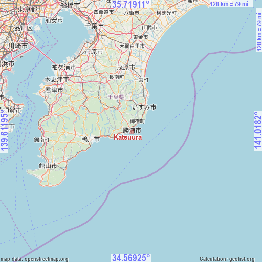
Katsuura GPS coordinates[2]
35° 8' 46.356" North, 140° 18' 54.252" East
| Map corner | latitude | longitude |
|---|---|---|
| Upper-left | 35.71911°, | 139.61195° |
| Center: | 35.14621°, | 140.31507° |
| Lower-right: | 34.56925°, | 141.0182° |
| Map W x H: | 127.9×127.9 km | = 79.5×79.5mi |
| max Lat: | 45.40944° ⇑55.2% North |
| Katsuura: | 35.14621° |
| min Lat: | ⇓44.8% South 24.34478° |
| min Long | Katsuura | max Long |
| 123° | 140.31507° | 145.575° |
| W 83.3%⇐ | ⇒16.7% E |
Elevation
Elevation of Katsuura is 23 m = 75 ft, and this is 61.6 m = 202 ft below average elevation for this country.
| Max E: |
1086 m = 3563 ft | 55.4% |
| Avg. | 84.6 m = 278 ft | |
| Katsuura | 23 m = 75 ft | |
Min E: |
-2 m = -7 ft | 44.6% |
See also: Japan elevation on elevation.city.
Geographical zone
Katsuura is located in North temperate zone (between Tropic of Cancer and the Arctic Circle). Distance of this Northern Tropic circle is 1302 km =809 mi to South.| Distance of | km | miles | from Katsuura |
|---|---|---|---|
| North Pole | 6099.2 | 3789.9 | to North |
| Arctic Circle | 3493.3 | 2170.6 | to North |
| Tropic Cancer | 1302 | 809 | to South |
| Equator | 3907.9 | 2428.3 | to South |


Nearby cities:
15 places around Katsuura: (largest is in red/bold)
• Futtsu
48.7 km =30.3 mi,  292°
292°
• Ichihara
46.2 km =28.7 mi,  332°
332°
• Isumi
12.4 km =7.7 mi,  41°
41°
• Kamogawa
20.3 km =12.6 mi,  254°
254°
• Kimitsu
46.3 km =28.8 mi,  299°
299°
• Kisarazu
43.6 km =27.1 mi,  307°
307°
• Minamibōsō
37.6 km =23.4 mi, 250°
• Mobara
31.1 km =19.3 mi,  356°
356°
• Narutō
51.3 km =31.9 mi,  10°
10°
• Sodegaura
39.9 km =24.8 mi,  318°
318°
• Tateyama
44.6 km =27.7 mi, 246°
• Tōgane
45.1 km =28 mi, 5°
• Ōami
41.2 km =25.6 mi,  0°
0°
• Ōamishirasato
40.8 km =25.4 mi, 4°
• Ōhara
13.3 km =8.3 mi,  32°
32°
Sources, notices
• [Note1] Compared only with cities in Japan existing in our database
• [Src1] Map data: © OpenStreetMap contributors (CC-BY-SA)
• [Src2] Other city data from geonames.org with taken over terms of usage.
• [Src3] Geographical zone / Annual Mean Temperature by Robert A. Rohde @ Wikipedia
