Namie geodata
Namie (Fukushima) is a populated place; located in Japan in Asia/Tokyo (GMT+9) time zone. With population of 21,866 people, there are 665 cities with bigger population in this country. Compared to other cities in Japan, 84.2% of cities are located further ↓South; 92.7% of cities are located further ←West and 65.3% of cities have higher elevation than Namie. Note1


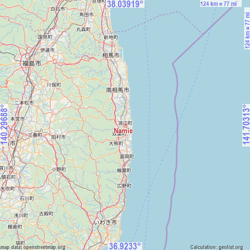
Namie GPS coordinates[2]
37° 28' 59.988" North, 141° 0' 0" East
| Map corner | latitude | longitude |
|---|---|---|
| Upper-left | 38.03919°, | 140.29688° |
| Center: | 37.48333°, | 141° |
| Lower-right: | 36.9233°, | 141.70313° |
| Map W x H: | 124.1×124.1 km | = 77.1×77.1mi |
| max Lat: | 45.40944° ⇑15.8% North |
| Namie: | 37.48333° |
| min Lat: | ⇓84.2% South 24.34478° |
| min Long | Namie | max Long |
| 123° | 141° | 145.575° |
| W 92.7%⇐ | ⇒7.3% E |
Elevation
Elevation of Namie is 15 m = 49 ft, and this is 69.6 m = 228 ft below average elevation for this country.
| Max E: |
1086 m = 3563 ft | 65.3% |
| Avg. | 84.6 m = 278 ft | |
| Namie | 15 m = 49 ft | |
Min E: |
-2 m = -7 ft | 34.7% |
See also: Japan elevation on elevation.city.
Geographical zone
Namie is located in North temperate zone (between Tropic of Cancer and the Arctic Circle). Distance of this Northern Tropic circle is 1561.8 km =970.5 mi to South.| Distance of | km | miles | from Namie |
|---|---|---|---|
| North Pole | 5839.3 | 3628.4 | to North |
| Arctic Circle | 3233.4 | 2009.1 | to North |
| Tropic Cancer | 1561.8 | 970.5 | to South |
| Equator | 4167.8 | 2589.8 | to South |


Nearby cities:
15 places around Namie: (largest is in red/bold)
• Date
57.5 km =35.7 mi,  310°
310°
• Fukushima
55.5 km =34.5 mi,  302°
302°
• Funehikimachi-funehiki
37.5 km =23.3 mi,  263°
263°
• Hobaramachi
54.3 km =33.7 mi, 313°
• Iwaki
49.3 km =30.6 mi,  192°
192°
• Kakuda
58.2 km =36.2 mi,  339°
339°
• Kōriyama
55.2 km =34.3 mi, 260°
• Marumori
52.4 km =32.6 mi, 336°
• Miharu
45.9 km =28.5 mi, 263°
• Minami-Sōma
16.3 km =10.1 mi,  353°
353°
• Motomiya
53 km =32.9 mi,  273°
273°
• Nihommatsu
51.2 km =31.8 mi,  282°
282°
• Sōma
35 km =21.7 mi, 349°
• Tamura
35.5 km =22.1 mi, 260°
• Yanagawamachi-saiwaichō
53.9 km =33.5 mi,  319°
319°
Sources, notices
• [Note1] Compared only with cities in Japan existing in our database
• [Src1] Map data: © OpenStreetMap contributors (CC-BY-SA)
• [Src2] Other city data from geonames.org with taken over terms of usage.
• [Src3] Geographical zone / Annual Mean Temperature by Robert A. Rohde @ Wikipedia
