Ishikawa geodata
Ishikawa (Fukushima) is a populated place; located in Japan in Asia/Tokyo (GMT+9) time zone. With population of 18,817 people, there are 712 cities with bigger population in this country. Compared to other cities in Japan, 83% of cities are located further ↓South; 86.2% of cities are located further ←West and 94% of cities have lower elevation than Ishikawa. Note1


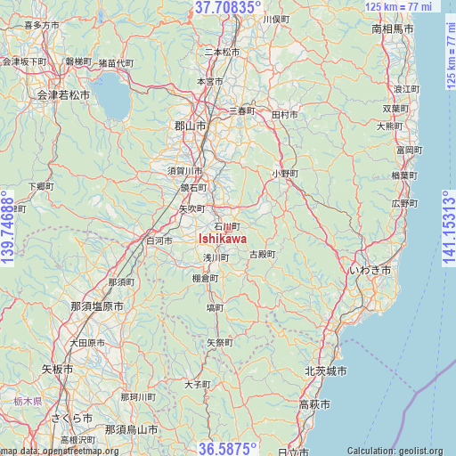
Ishikawa GPS coordinates[2]
37° 9' 0" North, 140° 27' 0" East
| Map corner | latitude | longitude |
|---|---|---|
| Upper-left | 37.70835°, | 139.74688° |
| Center: | 37.15°, | 140.45° |
| Lower-right: | 36.5875°, | 141.15313° |
| Map W x H: | 124.6×124.6 km | = 77.4×77.4mi |
| max Lat: | 45.40944° ⇑17% North |
| Ishikawa: | 37.15° |
| min Lat: | ⇓83% South 24.34478° |
| min Long | Ishikawa | max Long |
| 123° | 140.45° | 145.575° |
| W 86.2%⇐ | ⇒13.8% E |
Elevation
Elevation of Ishikawa is 330 m = 1083 ft, and this is 245.4 m = 805 ft above average elevation for this country.
| Max E: |
1086 m = 3563 ft | 6% |
| Ishikawa | 330 m 1083 ft | |
| Avg. | 84.6 m = 278 ft | |
Min E: |
-2 m = -7 ft | 94% |
See also: Japan elevation on elevation.city.
Geographical zone
Ishikawa is located in North temperate zone (between Tropic of Cancer and the Arctic Circle). Distance of this Northern Tropic circle is 1524.8 km =947.5 mi to South.| Distance of | km | miles | from Ishikawa |
|---|---|---|---|
| North Pole | 5876.4 | 3651.4 | to North |
| Arctic Circle | 3270.5 | 2032.2 | to North |
| Tropic Cancer | 1524.8 | 947.5 | to South |
| Equator | 4130.7 | 2566.7 | to South |


Nearby cities:
15 places around Ishikawa: (largest is in red/bold)
• Daigo
43.5 km =27 mi,  191°
191°
• Funehikimachi-funehiki
34.9 km =21.7 mi,  18°
18°
• Iwaki
40 km =24.9 mi,  106°
106°
• Kitaibaraki
48.3 km =30 mi,  146°
146°
• Kuroiso
40.9 km =25.4 mi,  240°
240°
• Kōriyama
28.4 km =17.6 mi,  348°
348°
• Miharu
31.6 km =19.6 mi,  5°
5°
• Motomiya
40.7 km =25.3 mi, 353°
• Nasushiobara
44.6 km =27.7 mi, 244°
• Nihommatsu
48.2 km =30 mi,  358°
358°
• Shirakawa
17 km =10.6 mi,  258°
258°
• Sukagawa
16 km =9.9 mi,  338°
338°
• Takahagi
53.7 km =33.4 mi, 153°
• Tamura
34 km =21.1 mi, 23°
• Ōtawara
48.6 km =30.2 mi,  229°
229°
Sources, notices
• [Note1] Compared only with cities in Japan existing in our database
• [Src1] Map data: © OpenStreetMap contributors (CC-BY-SA)
• [Src2] Other city data from geonames.org with taken over terms of usage.
• [Src3] Geographical zone / Annual Mean Temperature by Robert A. Rohde @ Wikipedia
