Furano geodata
Furano (Hokkaido) is a seat of a second-order administrative division; located in Japan in Asia/Tokyo (GMT+9) time zone. In our database, there are 767 cities with bigger population. Compared to other cities in Japan, 98.1% of cities are located further ↓South; 98.7% of cities are located further ←West and 84.8% of cities have lower elevation than Furano. Note1


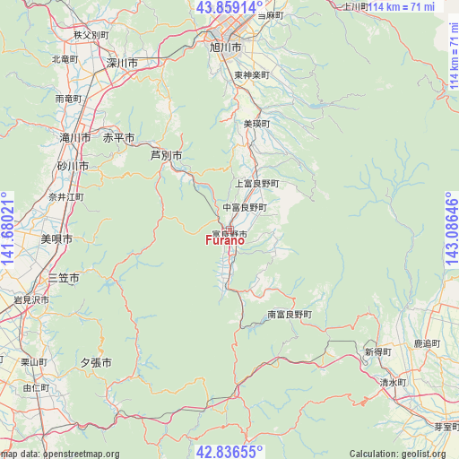
Furano GPS coordinates[2]
43° 21' 0" North, 142° 22' 59.988" East
| Map corner | latitude | longitude |
|---|---|---|
| Upper-left | 43.85914°, | 141.68021° |
| Center: | 43.35°, | 142.38333° |
| Lower-right: | 42.83655°, | 143.08646° |
| Map W x H: | 113.7×113.7 km | = 70.6×70.6mi |
| max Lat: | 45.40944° ⇑1.9% North |
| Furano: | 43.35° |
| min Lat: | ⇓98.1% South 24.34478° |
| min Long | Furano | max Long |
| 123° | 142.38333° | 145.575° |
| W 98.7%⇐ | ⇒1.3% E |
Elevation
Elevation of Furano is 170 m = 558 ft, and this is 85.4 m = 280 ft above average elevation for this country.
| Max E: |
1086 m = 3563 ft | 15.2% |
| Furano | 170 m 558 ft | |
| Avg. | 84.6 m = 278 ft | |
Min E: |
-2 m = -7 ft | 84.8% |
See also: Japan elevation on elevation.city.
Geographical zone
Furano is located in North temperate zone (between Tropic of Cancer and the Arctic Circle). Distance of this Northern Tropic circle is 2214.1 km =1375.8 mi to South.| Distance of | km | miles | from Furano |
|---|---|---|---|
| North Pole | 5187 | 3223.1 | to North |
| Arctic Circle | 2581.1 | 1603.8 | to North |
| Tropic Cancer | 2214.1 | 1375.8 | to South |
| Equator | 4820.1 | 2995.1 | to South |


Nearby cities:
15 places around Furano: (largest is in red/bold)
• Akabira
34.8 km =21.6 mi,  310°
310°
• Asahikawa
46.8 km =29.1 mi,  358°
358°
• Ashibetsu
23.9 km =14.9 mi,  318°
318°
• Bibai
42.5 km =26.4 mi,  266°
266°
• Ebetsu
72.6 km =45.1 mi,  248°
248°
• Fukagawa
48.5 km =30.1 mi,  325°
325°
• Iwamizawa
53.2 km =33.1 mi, 251°
• Kamikawa
62.8 km =39 mi,  29°
29°
• Mikasa
41.4 km =25.7 mi,  255°
255°
• Shimo-furano
0 km =0 mi,  0°
0°
• Sunagawa
41.5 km =25.8 mi,  291°
291°
• Takikawa
44.6 km =27.7 mi,  300°
300°
• Tōbetsu
71.7 km =44.6 mi, 258°
• Utashinai
32.7 km =20.3 mi, 304°
• Yūbari
48.9 km =30.4 mi,  224°
224°
Sources, notices
• [Note1] Compared only with cities in Japan existing in our database
• [Src1] Map data: © OpenStreetMap contributors (CC-BY-SA)
• [Src2] Other city data from geonames.org with taken over terms of usage.
• [Src3] Geographical zone / Annual Mean Temperature by Robert A. Rohde @ Wikipedia
