Mooka geodata
Mooka (Tochigi) is a seat of a second-order administrative division; located in Japan in Asia/Tokyo (GMT+9) time zone. With population of 65,717 people, there are 298 cities with bigger population in this country. Compared to other cities in Japan, 76.5% of cities are located further ↓South; 79% of cities are located further ←West and 68.8% of cities have lower elevation than Mooka. Note1


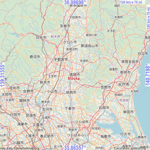
Mooka GPS coordinates[2]
36° 25' 59.988" North, 140° 1' 0.012" East
| Map corner | latitude | longitude |
|---|---|---|
| Upper-left | 36.99696°, | 139.31355° |
| Center: | 36.43333°, | 140.01667° |
| Lower-right: | 35.86557°, | 140.7198° |
| Map W x H: | 125.8×125.8 km | = 78.2×78.2mi |
| max Lat: | 45.40944° ⇑23.5% North |
| Mooka: | 36.43333° |
| min Lat: | ⇓76.5% South 24.34478° |
| min Long | Mooka | max Long |
| 123° | 140.01667° | 145.575° |
| W 79%⇐ | ⇒21% E |
Elevation
Elevation of Mooka is 67 m = 220 ft, and this is 17.6 m = 58 ft below average elevation for this country.
| Max E: |
1086 m = 3563 ft | 31.2% |
| Avg. | 84.6 m = 278 ft | |
| Mooka | 67 m = 220 ft | |
Min E: |
-2 m = -7 ft | 68.8% |
See also: Mooka elevation on elevation.city.
Geographical zone
Mooka is located in North temperate zone (between Tropic of Cancer and the Arctic Circle). Distance of this Northern Tropic circle is 1445.1 km =897.9 mi to South.| Distance of | km | miles | from Mooka |
|---|---|---|---|
| North Pole | 5956.1 | 3700.9 | to North |
| Arctic Circle | 3350.2 | 2081.7 | to North |
| Tropic Cancer | 1445.1 | 897.9 | to South |
| Equator | 4051 | 2517.2 | to South |


Nearby cities:
15 places around Mooka: (largest is in red/bold)
• Chikusei
13.4 km =8.3 mi,  193°
193°
• Iwase
11.9 km =7.4 mi,  141°
141°
• Kaminokawa
8.9 km =5.5 mi,  270°
270°
• Kasama
23.1 km =14.4 mi,  103°
103°
• Makabe
20 km =12.4 mi,  158°
158°
• Mashiko
8.3 km =5.2 mi,  63°
63°
• Mibu
19.5 km =12.1 mi,  264°
264°
• Motegi
17.5 km =10.9 mi, 58°
• Oyama
24.4 km =15.2 mi,  232°
232°
• Sakuragawa
22.2 km =13.8 mi, 156°
• Shimodate
15.1 km =9.4 mi, 191°
• Shimotsuke
13.6 km =8.5 mi, 260°
• Tochigi
26 km =16.2 mi, 257°
• Utsunomiya
19 km =11.8 mi,  321°
321°
• Yūki
19 km =11.8 mi,  218°
218°
Sources, notices
• [Note1] Compared only with cities in Japan existing in our database
• [Src1] Map data: © OpenStreetMap contributors (CC-BY-SA)
• [Src2] Other city data from geonames.org with taken over terms of usage.
• [Src3] Geographical zone / Annual Mean Temperature by Robert A. Rohde @ Wikipedia
