Kasama geodata
Kasama (Ibaraki) is a seat of a second-order administrative division; located in Japan in Asia/Tokyo (GMT+9) time zone. With population of 29,477 people, there are 552 cities with bigger population in this country. Compared to other cities in Japan, 75.3% of cities are located further ↓South; 82.6% of cities are located further ←West and 85.7% of cities have lower elevation than Kasama. Note1


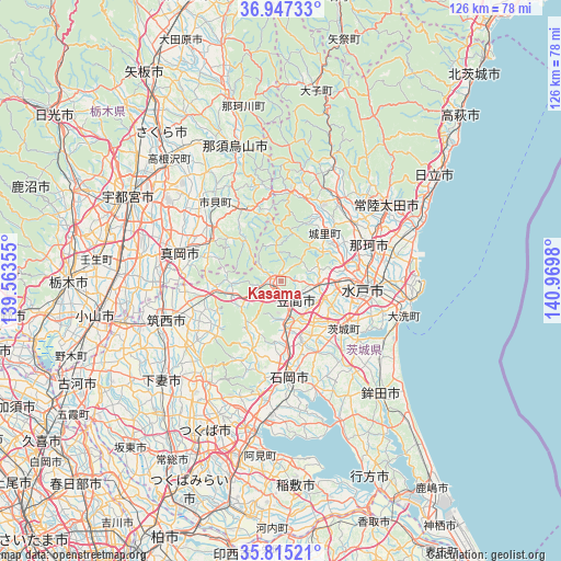
Kasama GPS coordinates[2]
36° 22' 59.988" North, 140° 16' 0.012" East
| Map corner | latitude | longitude |
|---|---|---|
| Upper-left | 36.94733°, | 139.56355° |
| Center: | 36.38333°, | 140.26667° |
| Lower-right: | 35.81521°, | 140.9698° |
| Map W x H: | 125.9×125.9 km | = 78.2×78.2mi |
| max Lat: | 45.40944° ⇑24.7% North |
| Kasama: | 36.38333° |
| min Lat: | ⇓75.3% South 24.34478° |
| min Long | Kasama | max Long |
| 123° | 140.26667° | 145.575° |
| W 82.6%⇐ | ⇒17.4% E |
Elevation
Elevation of Kasama is 177 m = 581 ft, and this is 92.4 m = 303 ft above average elevation for this country.
| Max E: |
1086 m = 3563 ft | 14.3% |
| Kasama | 177 m 581 ft | |
| Avg. | 84.6 m = 278 ft | |
Min E: |
-2 m = -7 ft | 85.7% |
See also: Japan elevation on elevation.city.
Geographical zone
Kasama is located in North temperate zone (between Tropic of Cancer and the Arctic Circle). Distance of this Northern Tropic circle is 1439.5 km =894.5 mi to South.| Distance of | km | miles | from Kasama |
|---|---|---|---|
| North Pole | 5961.6 | 3704.4 | to North |
| Arctic Circle | 3355.7 | 2085.1 | to North |
| Tropic Cancer | 1439.5 | 894.5 | to South |
| Equator | 4045.4 | 2513.7 | to South |


Nearby cities:
15 places around Kasama: (largest is in red/bold)
• Hitachi-Naka
24 km =14.9 mi,  86°
86°
• Hitachiomiya
23.5 km =14.6 mi,  31°
31°
• Ishioka
22.2 km =13.8 mi,  180°
180°
• Iwase
15.4 km =9.6 mi,  256°
256°
• Katsuta
23.9 km =14.9 mi, 90°
• Makabe
19.8 km =12.3 mi,  229°
229°
• Mashiko
17.6 km =10.9 mi,  301°
301°
• Mito
16.8 km =10.4 mi,  102°
102°
• Mooka
23.1 km =14.4 mi,  283°
283°
• Motegi
16.6 km =10.3 mi,  333°
333°
• Okunoya
17.4 km =10.8 mi,  129°
129°
• Omitama
17.5 km =10.9 mi,  144°
144°
• Sakuragawa
20 km =12.4 mi,  222°
222°
• Tomobe
4.8 km =3 mi, 141°
• Ōmiya
22.9 km =14.2 mi,  35°
35°
Sources, notices
• [Note1] Compared only with cities in Japan existing in our database
• [Src1] Map data: © OpenStreetMap contributors (CC-BY-SA)
• [Src2] Other city data from geonames.org with taken over terms of usage.
• [Src3] Geographical zone / Annual Mean Temperature by Robert A. Rohde @ Wikipedia
