Kōka geodata
Kōka (Shiga) is a seat of a second-order administrative division; located in Japan in Asia/Tokyo (GMT+9) time zone. In our database, there are 767 cities with bigger population. Compared to other cities in Japan, 59.6% of cities are located further ↑North; 60.5% of cities are located further →East and 84.8% of cities have lower elevation than Kōka. Note1


Kōka GPS coordinates[2]
34° 58' 48.72" North, 136° 9' 27.072" East
| Map corner | latitude | longitude |
|---|---|---|
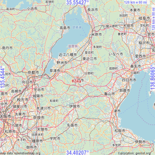
| Upper-left | 35.55427°, | 135.4544° |
| Center: | 34.9802°, | 136.15752° |
| Lower-right: | 34.40207°, | 136.86065° |
| Map W x H: | 128.1×128.1 km | = 79.6×79.6mi |
| max Lat: | 45.40944° ⇑59.6% North |
| Kōka: | 34.9802° |
| min Lat: | ⇓40.4% South 24.34478° |
| min Long | Kōka | max Long |
| 123° | 136.15752° | 145.575° |
| W 39.5%⇐ | ⇒60.5% E |
Elevation
Elevation of Kōka is 170 m = 558 ft, and this is 85.4 m = 280 ft above average elevation for this country.
| Max E: |
1086 m = 3563 ft | 15.2% |
| Kōka | 170 m 558 ft | |
| Avg. | 84.6 m = 278 ft | |
Min E: |
-2 m = -7 ft | 84.8% |
See also: Japan elevation on elevation.city.
Geographical zone
Kōka is located in North temperate zone (between Tropic of Cancer and the Arctic Circle). Distance of this Northern Tropic circle is 1283.5 km =797.5 mi to South.| Distance of | km | miles | from Kōka |
|---|---|---|---|
| North Pole | 6117.6 | 3801.3 | to North |
| Arctic Circle | 3511.7 | 2182.1 | to North |
| Tropic Cancer | 1283.5 | 797.5 | to South |
| Equator | 3889.4 | 2416.8 | to South |


Nearby cities:
15 places around Kōka: (largest is in red/bold)
• Higashiōmi
16.8 km =10.4 mi,  34°
34°
• Hino
8.7 km =5.4 mi,  75°
75°
• Iga
24.8 km =15.4 mi,  184°
184°
• Kameyama
30.3 km =18.8 mi,  118°
118°
• Kitahama
30.2 km =18.8 mi,  313°
313°
• Konan
5.9 km =3.7 mi,  290°
290°
• Kusatsu
17.8 km =11.1 mi,  283°
283°
• Minakuchichō-matoba
1.7 km =1.1 mi,  151°
151°
• Moriyama
18.5 km =11.5 mi,  301°
301°
• Rittō
15.3 km =9.5 mi, 290°
• Ueno-ebisumachi
24.8 km =15.4 mi,  185°
185°
• Yasu
18.5 km =11.5 mi,  316°
316°
• Youkaichi
15.6 km =9.7 mi,  13°
13°
• Ōmihachiman
17.4 km =10.8 mi,  341°
341°
• Ōtsu
26.6 km =16.5 mi,  274°
274°
Sources, notices
• [Note1] Compared only with cities in Japan existing in our database
• [Src1] Map data: © OpenStreetMap contributors (CC-BY-SA)
• [Src2] Other city data from geonames.org with taken over terms of usage.
• [Src3] Geographical zone / Annual Mean Temperature by Robert A. Rohde @ Wikipedia
