Moriyama geodata
Moriyama (Shiga) is a seat of a second-order administrative division; located in Japan in Asia/Tokyo (GMT+9) time zone. With population of 68,584 people, there are 284 cities with bigger population in this country. Compared to other cities in Japan, 57% of cities are located further ↑North; 61.7% of cities are located further →East and 74.1% of cities have lower elevation than Moriyama. Note1


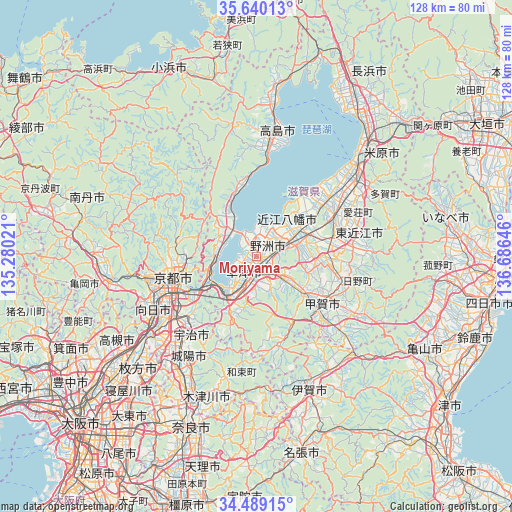
Moriyama GPS coordinates[2]
35° 4' 0.012" North, 135° 58' 59.988" East
| Map corner | latitude | longitude |
|---|---|---|
| Upper-left | 35.64013°, | 135.28021° |
| Center: | 35.06667°, | 135.98333° |
| Lower-right: | 34.48915°, | 136.68646° |
| Map W x H: | 128×128 km | = 79.5×79.5mi |
| max Lat: | 45.40944° ⇑57% North |
| Moriyama: | 35.06667° |
| min Lat: | ⇓43% South 24.34478° |
| min Long | Moriyama | max Long |
| 123° | 135.98333° | 145.575° |
| W 38.3%⇐ | ⇒61.7% E |
Elevation
Elevation of Moriyama is 92 m = 302 ft, and this is 7.4 m = 24 ft above average elevation for this country.
| Max E: |
1086 m = 3563 ft | 25.9% |
| Moriyama | 92 m 302 ft | |
| Avg. | 84.6 m = 278 ft | |
Min E: |
-2 m = -7 ft | 74.1% |
See also: Moriyama elevation on elevation.city.
Geographical zone
Moriyama is located in North temperate zone (between Tropic of Cancer and the Arctic Circle). Distance of this Northern Tropic circle is 1293.1 km =803.5 mi to South.| Distance of | km | miles | from Moriyama |
|---|---|---|---|
| North Pole | 6108 | 3795.3 | to North |
| Arctic Circle | 3502.1 | 2176.1 | to North |
| Tropic Cancer | 1293.1 | 803.5 | to South |
| Equator | 3899 | 2422.7 | to South |


Nearby cities:
15 places around Moriyama: (largest is in red/bold)
• Higashiōmi
25.8 km =16 mi,  80°
80°
• Hino
25.4 km =15.8 mi,  106°
106°
• Kamigyō-ku
21 km =13 mi,  258°
258°
• Kitahama
12.7 km =7.9 mi,  331°
331°
• Konan
12.8 km =8 mi,  125°
125°
• Kusatsu
5.8 km =3.6 mi,  195°
195°
• Kyoto
21.5 km =13.4 mi, 256°
• Kōka
18.5 km =11.5 mi,  121°
121°
• Minakuchichō-matoba
20.1 km =12.5 mi, 123°
• Rittō
4.6 km =2.9 mi,  161°
161°
• Uji
25.6 km =15.9 mi,  219°
219°
• Yasu
4.9 km =3 mi,  39°
39°
• Youkaichi
20.3 km =12.6 mi,  74°
74°
• Ōmihachiman
12.5 km =7.8 mi,  56°
56°
• Ōtsu
13 km =8.1 mi,  235°
235°
Sources, notices
• [Note1] Compared only with cities in Japan existing in our database
• [Src1] Map data: © OpenStreetMap contributors (CC-BY-SA)
• [Src2] Other city data from geonames.org with taken over terms of usage.
• [Src3] Geographical zone / Annual Mean Temperature by Robert A. Rohde @ Wikipedia
