Ueno-ebisumachi geodata
Ueno-ebisumachi (Mie) is a populated place; located in Japan in Asia/Tokyo (GMT+9) time zone. With population of 61,598 people, there are 317 cities with bigger population in this country. Compared to other cities in Japan, 66.6% of cities are located further ↑North; 60.7% of cities are located further →East and 82.9% of cities have lower elevation than Ueno-ebisumachi. Note1


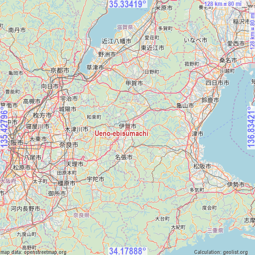
Ueno-ebisumachi GPS coordinates[2]
34° 45' 30.816" North, 136° 7' 51.888" East
| Map corner | latitude | longitude |
|---|---|---|
| Upper-left | 35.33419°, | 135.42796° |
| Center: | 34.75856°, | 136.13108° |
| Lower-right: | 34.17888°, | 136.83421° |
| Map W x H: | 128.5×128.5 km | = 79.8×79.8mi |
| max Lat: | 45.40944° ⇑66.6% North |
| Ueno-ebisumachi: | 34.75856° |
| min Lat: | ⇓33.4% South 24.34478° |
| min Long | Ueno-ebisumachi | max Long |
| 123° | 136.13108° | 145.575° |
| W 39.3%⇐ | ⇒60.7% E |
Elevation
Elevation of Ueno-ebisumachi is 149 m = 489 ft, and this is 64.4 m = 211 ft above average elevation for this country.
| Max E: |
1086 m = 3563 ft | 17.1% |
| Ueno-ebisumachi | 149 m 489 ft | |
| Avg. | 84.6 m = 278 ft | |
Min E: |
-2 m = -7 ft | 82.9% |
See also: Ueno-ebisumachi elevation on elevation.city.
Geographical zone
Ueno-ebisumachi is located in North temperate zone (between Tropic of Cancer and the Arctic Circle). Distance of this Northern Tropic circle is 1258.9 km =782.2 mi to South.| Distance of | km | miles | from Ueno-ebisumachi |
|---|---|---|---|
| North Pole | 6142.3 | 3816.6 | to North |
| Arctic Circle | 3536.4 | 2197.4 | to North |
| Tropic Cancer | 1258.9 | 782.2 | to South |
| Equator | 3864.8 | 2401.5 | to South |


Nearby cities:
15 places around Ueno-ebisumachi: (largest is in red/bold)
• Haibara-akanedai
30 km =18.6 mi,  213°
213°
• Hino
29 km =18 mi,  22°
22°
• Hisai-motomachi
32.3 km =20.1 mi,  108°
108°
• Iga
0.3 km =0.2 mi,  101°
101°
• Jōyō
31.2 km =19.4 mi,  287°
287°
• Kameyama
30.8 km =19.1 mi,  70°
70°
• Kizugawa
26.7 km =16.6 mi,  264°
264°
• Konan
26.9 km =16.7 mi,  353°
353°
• Kusatsu
32.4 km =20.1 mi,  332°
332°
• Kōka
24.8 km =15.4 mi,  5°
5°
• Minakuchichō-matoba
23.4 km =14.5 mi, 7°
• Nabari
16.4 km =10.2 mi,  195°
195°
• Nara-shi
30.9 km =19.2 mi,  254°
254°
• Rittō
32.2 km =20 mi,  338°
338°
• Uji
33.3 km =20.7 mi,  296°
296°
Sources, notices
• [Note1] Compared only with cities in Japan existing in our database
• [Src1] Map data: © OpenStreetMap contributors (CC-BY-SA)
• [Src2] Other city data from geonames.org with taken over terms of usage.
• [Src3] Geographical zone / Annual Mean Temperature by Robert A. Rohde @ Wikipedia
