Minokamo geodata
Minokamo (Gifu) is a seat of a second-order administrative division; located in Japan in Asia/Tokyo (GMT+9) time zone. With population of 51,543 people, there are 367 cities with bigger population in this country. Compared to other cities in Japan, 52.7% of cities are located further ↓South; 51.4% of cities are located further →East and 85.4% of cities have lower elevation than Minokamo. Note1


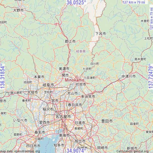
Minokamo GPS coordinates[2]
35° 28' 55.164" North, 137° 1' 17.976" East
| Map corner | latitude | longitude |
|---|---|---|
| Upper-left | 36.0525°, | 136.31854° |
| Center: | 35.48199°, | 137.02166° |
| Lower-right: | 34.9074°, | 137.72479° |
| Map W x H: | 127.3×127.3 km | = 79.1×79.1mi |
| max Lat: | 45.40944° ⇑47.3% North |
| Minokamo: | 35.48199° |
| min Lat: | ⇓52.7% South 24.34478° |
| min Long | Minokamo | max Long |
| 123° | 137.02166° | 145.575° |
| W 48.6%⇐ | ⇒51.4% E |
Elevation
Elevation of Minokamo is 175 m = 574 ft, and this is 90.4 m = 297 ft above average elevation for this country.
| Max E: |
1086 m = 3563 ft | 14.6% |
| Minokamo | 175 m 574 ft | |
| Avg. | 84.6 m = 278 ft | |
Min E: |
-2 m = -7 ft | 85.4% |
See also: Minokamo elevation on elevation.city.
Geographical zone
Minokamo is located in North temperate zone (between Tropic of Cancer and the Arctic Circle). Distance of this Northern Tropic circle is 1339.3 km =832.2 mi to South.| Distance of | km | miles | from Minokamo |
|---|---|---|---|
| North Pole | 6061.8 | 3766.6 | to North |
| Arctic Circle | 3455.9 | 2147.4 | to North |
| Tropic Cancer | 1339.3 | 832.2 | to South |
| Equator | 3945.2 | 2451.4 | to South |


Nearby cities:
15 places around Minokamo: (largest is in red/bold)
• Gifu-shi
24.6 km =15.3 mi,  254°
254°
• Inuyama
13.4 km =8.3 mi,  212°
212°
• Iwakura
26.2 km =16.3 mi, 212°
• Kakamigahara
15.8 km =9.8 mi,  242°
242°
• Kani
9.2 km =5.7 mi,  160°
160°
• Komaki
24.1 km =15 mi,  203°
203°
• Kuroda
26.1 km =16.2 mi, 235°
• Kōnan
21.6 km =13.4 mi,  219°
219°
• Mino
11.1 km =6.9 mi,  300°
300°
• Mitake
12.5 km =7.8 mi,  125°
125°
• Mizunami
24.3 km =15.1 mi,  121°
121°
• Sekimachi
9.5 km =5.9 mi,  270°
270°
• Tajimi
21 km =13 mi,  151°
151°
• Toki
20.7 km =12.9 mi,  135°
135°
• Yamagata
26.3 km =16.3 mi, 295°
Sources, notices
• [Note1] Compared only with cities in Japan existing in our database
• [Src1] Map data: © OpenStreetMap contributors (CC-BY-SA)
• [Src2] Other city data from geonames.org with taken over terms of usage.
• [Src3] Geographical zone / Annual Mean Temperature by Robert A. Rohde @ Wikipedia
