Kasukabe geodata
Kasukabe (Saitama) is a seat of a second-order administrative division; located in Japan in Asia/Tokyo (GMT+9) time zone. With population of 206,915 people, there are 98 cities with bigger population in this country. Compared to other cities in Japan, 67.1% of cities are located further ↓South; 74.2% of cities are located further ←West and 79% of cities have higher elevation than Kasukabe. Note1


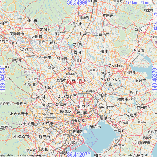
Kasukabe GPS coordinates[2]
35° 58' 59.088" North, 139° 44' 58.776" East
| Map corner | latitude | longitude |
|---|---|---|
| Upper-left | 36.54999°, | 139.04654° |
| Center: | 35.98308°, | 139.74966° |
| Lower-right: | 35.41207°, | 140.45279° |
| Map W x H: | 126.5×126.5 km | = 78.6×78.6mi |
| max Lat: | 45.40944° ⇑32.9% North |
| Kasukabe: | 35.98308° |
| min Lat: | ⇓67.1% South 24.34478° |
| min Long | Kasukabe | max Long |
| 123° | 139.74966° | 145.575° |
| W 74.2%⇐ | ⇒25.8% E |
Elevation
Elevation of Kasukabe is 8 m = 26 ft, and this is 76.6 m = 251 ft below average elevation for this country.
| Max E: |
1086 m = 3563 ft | 79% |
| Avg. | 84.6 m = 278 ft | |
| Kasukabe | 8 m = 26 ft | |
Min E: |
-2 m = -7 ft | 21% |
See also: Kasukabe elevation on elevation.city.
Geographical zone
Kasukabe is located in North temperate zone (between Tropic of Cancer and the Arctic Circle). Distance of this Northern Tropic circle is 1395 km =866.8 mi to South.| Distance of | km | miles | from Kasukabe |
|---|---|---|---|
| North Pole | 6006.1 | 3732 | to North |
| Arctic Circle | 3400.2 | 2112.8 | to North |
| Tropic Cancer | 1395 | 866.8 | to South |
| Equator | 4000.9 | 2486 | to South |


Nearby cities:
15 places around Kasukabe: (largest is in red/bold)
• Ageoshimo
12.3 km =7.6 mi,  263°
263°
• Bandō
14.3 km =8.9 mi,  47°
47°
• Hasuda
9.1 km =5.7 mi, 261°
• Iwai
15.4 km =9.6 mi,  61°
61°
• Iwatsuki
5.2 km =3.2 mi,  246°
246°
• Koshigaya
10.9 km =6.8 mi,  160°
160°
• Kukichūō
11.5 km =7.1 mi,  324°
324°
• Noda
11.3 km =7 mi,  109°
109°
• Saitama
11.8 km =7.3 mi,  225°
225°
• Sakai
13.8 km =8.6 mi,  19°
19°
• Satte
10.2 km =6.3 mi,  348°
348°
• Shiraoka
8.9 km =5.5 mi,  296°
296°
• Sugito
5.7 km =3.5 mi,  338°
338°
• Yono
15.3 km =9.5 mi,  223°
223°
• Yoshikawa
13.1 km =8.1 mi,  140°
140°
Sources, notices
• [Note1] Compared only with cities in Japan existing in our database
• [Src1] Map data: © OpenStreetMap contributors (CC-BY-SA)
• [Src2] Other city data from geonames.org with taken over terms of usage.
• [Src3] Geographical zone / Annual Mean Temperature by Robert A. Rohde @ Wikipedia
