Hasuda geodata
Hasuda (Saitama) is a seat of a second-order administrative division; located in Japan in Asia/Tokyo (GMT+9) time zone. With population of 65,161 people, there are 302 cities with bigger population in this country. Compared to other cities in Japan, 66.7% of cities are located further ↓South; 72.2% of cities are located further ←West and 68.3% of cities have higher elevation than Hasuda. Note1


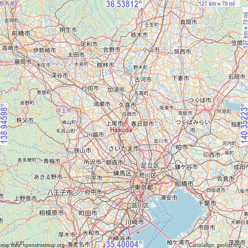
Hasuda GPS coordinates[2]
35° 58' 16.068" North, 139° 38' 56.76" East
| Map corner | latitude | longitude |
|---|---|---|
| Upper-left | 36.53812°, | 138.94598° |
| Center: | 35.97113°, | 139.6491° |
| Lower-right: | 35.40004°, | 140.35223° |
| Map W x H: | 126.5×126.5 km | = 78.6×78.6mi |
| max Lat: | 45.40944° ⇑33.3% North |
| Hasuda: | 35.97113° |
| min Lat: | ⇓66.7% South 24.34478° |
| min Long | Hasuda | max Long |
| 123° | 139.6491° | 145.575° |
| W 72.2%⇐ | ⇒27.8% E |
Elevation
Elevation of Hasuda is 13 m = 43 ft, and this is 71.6 m = 235 ft below average elevation for this country.
| Max E: |
1086 m = 3563 ft | 68.3% |
| Avg. | 84.6 m = 278 ft | |
| Hasuda | 13 m = 43 ft | |
Min E: |
-2 m = -7 ft | 31.7% |
See also: Hasuda elevation on elevation.city.
Geographical zone
Hasuda is located in North temperate zone (between Tropic of Cancer and the Arctic Circle). Distance of this Northern Tropic circle is 1393.7 km =866 mi to South.| Distance of | km | miles | from Hasuda |
|---|---|---|---|
| North Pole | 6007.4 | 3732.8 | to North |
| Arctic Circle | 3401.6 | 2113.7 | to North |
| Tropic Cancer | 1393.7 | 866 | to South |
| Equator | 3999.6 | 2485.2 | to South |


Nearby cities:
15 places around Hasuda: (largest is in red/bold)
• Ageoshimo
3.2 km =2 mi,  270°
270°
• Fujimi
16.1 km =10 mi,  211°
211°
• Iwatsuki
4.3 km =2.7 mi,  99°
99°
• Kasukabe
9.1 km =5.7 mi,  81°
81°
• Kisai
15.5 km =9.6 mi,  337°
337°
• Kitamoto
12.2 km =7.6 mi,  304°
304°
• Koshigaya
15.5 km =9.6 mi,  125°
125°
• Kukichūō
11 km =6.8 mi,  12°
12°
• Okegawa
8.9 km =5.5 mi,  291°
291°
• Saitama
7 km =4.3 mi,  174°
174°
• Satte
13.2 km =8.2 mi,  31°
31°
• Shiraoka
5.4 km =3.4 mi, 10°
• Shōbu
11.5 km =7.1 mi, 337°
• Sugito
9.6 km =6 mi,  46°
46°
• Yono
9.9 km =6.2 mi,  188°
188°
Sources, notices
• [Note1] Compared only with cities in Japan existing in our database
• [Src1] Map data: © OpenStreetMap contributors (CC-BY-SA)
• [Src2] Other city data from geonames.org with taken over terms of usage.
• [Src3] Geographical zone / Annual Mean Temperature by Robert A. Rohde @ Wikipedia
