Hachijō geodata
Hachijō (Tokyo) is a seat of a second-order administrative division; located in Japan in Asia/Tokyo (GMT+9) time zone. In our database, there are 767 cities with bigger population. Compared to other cities in Japan, 90.3% of cities are located further ↑North; 74.3% of cities are located further ←West and 55.4% of cities have higher elevation than Hachijō. Note1


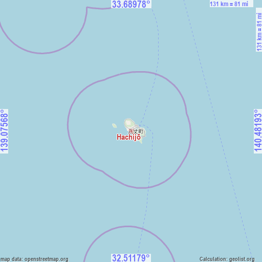
Hachijō GPS coordinates[2]
33° 6' 9.936" North, 139° 46' 43.68" East
| Map corner | latitude | longitude |
|---|---|---|
| Upper-left | 33.68978°, | 139.07568° |
| Center: | 33.10276°, | 139.7788° |
| Lower-right: | 32.51179°, | 140.48193° |
| Map W x H: | 131×131 km | = 81.4×81.4mi |
| max Lat: | 45.40944° ⇑90.3% North |
| Hachijō: | 33.10276° |
| min Lat: | ⇓9.7% South 24.34478° |
| min Long | Hachijō | max Long |
| 123° | 139.7788° | 145.575° |
| W 74.3%⇐ | ⇒25.7% E |
Elevation
Elevation of Hachijō is 23 m = 75 ft, and this is 61.6 m = 202 ft below average elevation for this country.
| Max E: |
1086 m = 3563 ft | 55.4% |
| Avg. | 84.6 m = 278 ft | |
| Hachijō | 23 m = 75 ft | |
Min E: |
-2 m = -7 ft | 44.6% |
See also: Japan elevation on elevation.city.
Geographical zone
Hachijō is located in North temperate zone (between Tropic of Cancer and the Arctic Circle). Distance of this Northern Tropic circle is 1074.8 km =667.8 mi to South.| Distance of | km | miles | from Hachijō |
|---|---|---|---|
| North Pole | 6326.4 | 3931 | to North |
| Arctic Circle | 3720.5 | 2311.8 | to North |
| Tropic Cancer | 1074.8 | 667.8 | to South |
| Equator | 3680.7 | 2287.1 | to South |


Nearby cities:
15 places around Hachijō: (largest is in red/bold)
• Atami
230.7 km =143.4 mi,  343°
343°
• Heda
226.2 km =140.6 mi, 336°
• Itō
216.9 km =134.8 mi, 342°
• Izu
221.5 km =137.6 mi, 339°
• Izunokuni
228.4 km =141.9 mi, 340°
• Kamogawa
223.7 km =139 mi,  7°
7°
• Minamibōsō
214.9 km =133.5 mi,  3°
3°
• Miura
227 km =141.1 mi,  356°
356°
• Miyake
112.4 km =69.8 mi,  347°
347°
• Omaezaki
220 km =136.7 mi,  319°
319°
• Sagara
228.2 km =141.8 mi, 320°
• Shimoda
191.2 km =118.8 mi, 336°
• Tateyama
209.3 km =130.1 mi, 2°
• Ōshima
186.9 km =116.1 mi, 348°
• Ōyama
220.5 km =137 mi, 319°
Sources, notices
• [Note1] Compared only with cities in Japan existing in our database
• [Src1] Map data: © OpenStreetMap contributors (CC-BY-SA)
• [Src2] Other city data from geonames.org with taken over terms of usage.
• [Src3] Geographical zone / Annual Mean Temperature by Robert A. Rohde @ Wikipedia
