Ōshima geodata
Ōshima (Tokyo) is a seat of a second-order administrative division; located in Japan in Asia/Tokyo (GMT+9) time zone. In our database, there are 767 cities with bigger population. Compared to other cities in Japan, 67.1% of cities are located further ↑North; 65.3% of cities are located further ←West and 69.4% of cities have lower elevation than Ōshima. Note1


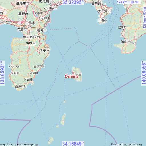
Ōshima GPS coordinates[2]
34° 44' 53.664" North, 139° 21' 44.748" East
| Map corner | latitude | longitude |
|---|---|---|
| Upper-left | 35.32395°, | 138.65931° |
| Center: | 34.74824°, | 139.36243° |
| Lower-right: | 34.16849°, | 140.06556° |
| Map W x H: | 128.5×128.5 km | = 79.8×79.8mi |
| max Lat: | 45.40944° ⇑67.1% North |
| Ōshima: | 34.74824° |
| min Lat: | ⇓32.9% South 24.34478° |
| min Long | Ōshima | max Long |
| 123° | 139.36243° | 145.575° |
| W 65.3%⇐ | ⇒34.7% E |
Elevation
Elevation of Ōshima is 70 m = 230 ft, and this is 14.6 m = 48 ft below average elevation for this country.
| Max E: |
1086 m = 3563 ft | 30.6% |
| Avg. | 84.6 m = 278 ft | |
| Ōshima | 70 m = 230 ft | |
Min E: |
-2 m = -7 ft | 69.4% |
See also: Japan elevation on elevation.city.
Geographical zone
Ōshima is located in North temperate zone (between Tropic of Cancer and the Arctic Circle). Distance of this Northern Tropic circle is 1257.7 km =781.5 mi to South.| Distance of | km | miles | from Ōshima |
|---|---|---|---|
| North Pole | 6143.4 | 3817.3 | to North |
| Arctic Circle | 3537.5 | 2198.1 | to North |
| Tropic Cancer | 1257.7 | 781.5 | to South |
| Equator | 3863.6 | 2400.7 | to South |


Nearby cities:
15 places around Ōshima: (largest is in red/bold)
• Atami
47.2 km =29.3 mi,  323°
323°
• Hakone
57.8 km =35.9 mi,  328°
328°
• Hayama
61.9 km =38.5 mi,  18°
18°
• Heda
57.8 km =35.9 mi,  294°
294°
• Itō
35.2 km =21.9 mi,  313°
313°
• Izu
45.4 km =28.2 mi,  303°
303°
• Izunokuni
49.5 km =30.8 mi, 310°
• Minamibōsō
60.3 km =37.5 mi,  58°
58°
• Mishima
57.7 km =35.9 mi, 315°
• Miura
49.4 km =30.7 mi,  28°
28°
• Numazu
59.8 km =37.2 mi, 310°
• Odawara
59.4 km =36.9 mi,  341°
341°
• Shimoda
39 km =24.2 mi,  258°
258°
• Tateyama
52.9 km =32.9 mi, 60°
• Yugawara
52.2 km =32.4 mi, 328°
Sources, notices
• [Note1] Compared only with cities in Japan existing in our database
• [Src1] Map data: © OpenStreetMap contributors (CC-BY-SA)
• [Src2] Other city data from geonames.org with taken over terms of usage.
• [Src3] Geographical zone / Annual Mean Temperature by Robert A. Rohde @ Wikipedia
