Kunisaki geodata
Kunisaki (Oita) is a seat of a second-order administrative division; located in Japan in Asia/Tokyo (GMT+9) time zone. In our database, there are 767 cities with bigger population. Compared to other cities in Japan, 84.8% of cities are located further ↑North; 83.4% of cities are located further →East and 53.2% of cities have higher elevation than Kunisaki. Note1


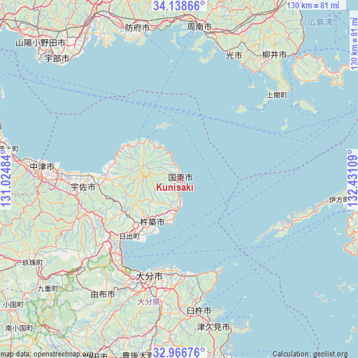
Kunisaki GPS coordinates[2]
33° 33' 16.92" North, 131° 43' 40.656" East
| Map corner | latitude | longitude |
|---|---|---|
| Upper-left | 34.13866°, | 131.02484° |
| Center: | 33.5547°, | 131.72796° |
| Lower-right: | 32.96676°, | 132.43109° |
| Map W x H: | 130.3×130.3 km | = 81×81mi |
| max Lat: | 45.40944° ⇑84.8% North |
| Kunisaki: | 33.5547° |
| min Lat: | ⇓15.2% South 24.34478° |
| min Long | Kunisaki | max Long |
| 123° | 131.72796° | 145.575° |
| W 16.6%⇐ | ⇒83.4% E |
Elevation
Elevation of Kunisaki is 25 m = 82 ft, and this is 59.6 m = 196 ft below average elevation for this country.
| Max E: |
1086 m = 3563 ft | 53.2% |
| Avg. | 84.6 m = 278 ft | |
| Kunisaki | 25 m = 82 ft | |
Min E: |
-2 m = -7 ft | 46.8% |
See also: Japan elevation on elevation.city.
Geographical zone
Kunisaki is located in North temperate zone (between Tropic of Cancer and the Arctic Circle). Distance of this Northern Tropic circle is 1125 km =699 mi to South.| Distance of | km | miles | from Kunisaki |
|---|---|---|---|
| North Pole | 6276.1 | 3899.8 | to North |
| Arctic Circle | 3670.2 | 2280.6 | to North |
| Tropic Cancer | 1125 | 699 | to South |
| Equator | 3730.9 | 2318.3 | to South |


Nearby cities:
15 places around Kunisaki: (largest is in red/bold)
• Beppu
37.3 km =23.2 mi,  214°
214°
• Bungo-Takada-shi
26.2 km =16.3 mi,  270°
270°
• Hiji
27.5 km =17.1 mi,  221°
221°
• Hikari
49 km =30.4 mi,  24°
24°
• Kitsuki
18.1 km =11.2 mi, 214°
• Kudamatsu
51.1 km =31.8 mi,  14°
14°
• Nakatsu
50.2 km =31.2 mi,  275°
275°
• Nakatsu
55.3 km =34.4 mi,  259°
259°
• Tsukumiura
54.9 km =34.1 mi,  166°
166°
• Tsurusaki
34.6 km =21.5 mi,  185°
185°
• Usa
38.5 km =23.9 mi,  250°
250°
• Usuki
48.5 km =30.1 mi, 171°
• Yoshitomi
51.4 km =31.9 mi, 275°
• Yufu
51.5 km =32 mi, 219°
• Ōita
37.7 km =23.4 mi,  198°
198°
Sources, notices
• [Note1] Compared only with cities in Japan existing in our database
• [Src1] Map data: © OpenStreetMap contributors (CC-BY-SA)
• [Src2] Other city data from geonames.org with taken over terms of usage.
• [Src3] Geographical zone / Annual Mean Temperature by Robert A. Rohde @ Wikipedia
