Tsukumiura geodata
Tsukumiura (Oita) is a seat of a second-order administrative division; located in Japan in Asia/Tokyo (GMT+9) time zone. With population of 21,658 people, there are 669 cities with bigger population in this country. Compared to other cities in Japan, 90.5% of cities are located further ↑North; 82.8% of cities are located further →East and 68.3% of cities have higher elevation than Tsukumiura. Note1


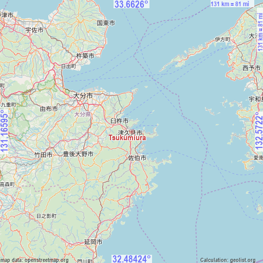
Tsukumiura GPS coordinates[2]
33° 4' 31.404" North, 131° 52' 8.652" East
| Map corner | latitude | longitude |
|---|---|---|
| Upper-left | 33.6626°, | 131.16595° |
| Center: | 33.07539°, | 131.86907° |
| Lower-right: | 32.48424°, | 132.5722° |
| Map W x H: | 131×131 km | = 81.4×81.4mi |
| max Lat: | 45.40944° ⇑90.5% North |
| Tsukumiura: | 33.07539° |
| min Lat: | ⇓9.5% South 24.34478° |
| min Long | Tsukumiura | max Long |
| 123° | 131.86907° | 145.575° |
| W 17.2%⇐ | ⇒82.8% E |
Elevation
Elevation of Tsukumiura is 13 m = 43 ft, and this is 71.6 m = 235 ft below average elevation for this country.
| Max E: |
1086 m = 3563 ft | 68.3% |
| Avg. | 84.6 m = 278 ft | |
| Tsukumiura | 13 m = 43 ft | |
Min E: |
-2 m = -7 ft | 31.7% |
See also: Japan elevation on elevation.city.
Geographical zone
Tsukumiura is located in North temperate zone (between Tropic of Cancer and the Arctic Circle). Distance of this Northern Tropic circle is 1071.7 km =665.9 mi to South.| Distance of | km | miles | from Tsukumiura |
|---|---|---|---|
| North Pole | 6329.4 | 3932.9 | to North |
| Arctic Circle | 3723.5 | 2313.7 | to North |
| Tropic Cancer | 1071.7 | 665.9 | to South |
| Equator | 3677.6 | 2285.2 | to South |


Nearby cities:
15 places around Tsukumiura: (largest is in red/bold)
• Beppu
41.4 km =25.7 mi,  303°
303°
• Bungo-ōno
33.8 km =21 mi,  250°
250°
• Hiji
45.5 km =28.3 mi,  316°
316°
• Ikata-chō
64.4 km =40 mi,  44°
44°
• Kitsuki
44.8 km =27.8 mi,  328°
328°
• Kunisaki
54.9 km =34.1 mi,  346°
346°
• Nobeoka
57.9 km =36 mi,  199°
199°
• Saiki
14.2 km =8.8 mi,  168°
168°
• Takedamachi
45.4 km =28.2 mi, 254°
• Taketa
48.5 km =30.1 mi, 254°
• Tsurusaki
25.1 km =15.6 mi, 318°
• Usa
63.9 km =39.7 mi,  309°
309°
• Usuki
8.1 km =5 mi, 311°
• Yufu
47.6 km =29.6 mi,  286°
286°
• Ōita
30.6 km =19 mi, 305°
Sources, notices
• [Note1] Compared only with cities in Japan existing in our database
• [Src1] Map data: © OpenStreetMap contributors (CC-BY-SA)
• [Src2] Other city data from geonames.org with taken over terms of usage.
• [Src3] Geographical zone / Annual Mean Temperature by Robert A. Rohde @ Wikipedia
