Beppu geodata
Beppu (Oita) is a seat of a second-order administrative division; located in Japan in Asia/Tokyo (GMT+9) time zone. With population of 125,065 people, there are 169 cities with bigger population in this country. Compared to other cities in Japan, 88.2% of cities are located further ↑North; 84.3% of cities are located further →East and 56.6% of cities have higher elevation than Beppu. Note1


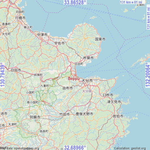
Beppu GPS coordinates[2]
33° 16' 46.02" North, 131° 29' 51.036" East
| Map corner | latitude | longitude |
|---|---|---|
| Upper-left | 33.86528°, | 130.79439° |
| Center: | 33.27945°, | 131.49751° |
| Lower-right: | 32.68966°, | 132.20064° |
| Map W x H: | 130.7×130.7 km | = 81.2×81.2mi |
| max Lat: | 45.40944° ⇑88.2% North |
| Beppu: | 33.27945° |
| min Lat: | ⇓11.8% South 24.34478° |
| min Long | Beppu | max Long |
| 123° | 131.49751° | 145.575° |
| W 15.7%⇐ | ⇒84.3% E |
Elevation
Elevation of Beppu is 22 m = 72 ft, and this is 62.6 m = 205 ft below average elevation for this country.
| Max E: |
1086 m = 3563 ft | 56.6% |
| Avg. | 84.6 m = 278 ft | |
| Beppu | 22 m = 72 ft | |
Min E: |
-2 m = -7 ft | 43.4% |
See also: Beppu elevation on elevation.city.
Geographical zone
Beppu is located in North temperate zone (between Tropic of Cancer and the Arctic Circle). Distance of this Northern Tropic circle is 1094.4 km =680 mi to South.| Distance of | km | miles | from Beppu |
|---|---|---|---|
| North Pole | 6306.7 | 3918.8 | to North |
| Arctic Circle | 3700.8 | 2299.6 | to North |
| Tropic Cancer | 1094.4 | 680 | to South |
| Equator | 3700.3 | 2299.3 | to South |


Nearby cities:
15 places around Beppu: (largest is in red/bold)
• Bungo-Takada-shi
31.2 km =19.4 mi,  351°
351°
• Bungo-ōno
34.4 km =21.4 mi,  175°
175°
• Hiji
10.6 km =6.6 mi,  16°
16°
• Kitsuki
19.2 km =11.9 mi,  35°
35°
• Kunisaki
37.3 km =23.2 mi,  34°
34°
• Nakatsu
38.8 km =24.1 mi,  301°
301°
• Takedamachi
35.9 km =22.3 mi,  194°
194°
• Taketa
37.6 km =23.4 mi,  198°
198°
• Tsukawaki
31.7 km =19.7 mi,  269°
269°
• Tsukumiura
41.4 km =25.7 mi,  123°
123°
• Tsurusaki
18.4 km =11.4 mi,  101°
101°
• Usa
23.2 km =14.4 mi,  319°
319°
• Usuki
33.4 km =20.8 mi, 121°
• Yufu
14.5 km =9 mi,  229°
229°
• Ōita
10.8 km =6.7 mi, 118°
Sources, notices
• [Note1] Compared only with cities in Japan existing in our database
• [Src1] Map data: © OpenStreetMap contributors (CC-BY-SA)
• [Src2] Other city data from geonames.org with taken over terms of usage.
• [Src3] Geographical zone / Annual Mean Temperature by Robert A. Rohde @ Wikipedia
