Batken geodata
Batken is a seat of a first-order administrative division; located in Kyrgyzstan in Asia/Bishkek (GMT+6) time zone. With population of 10,155 people, there are 30 cities with bigger population in this country. Compared to other cities in Kyrgyzstan, 77.4% of cities are located further ↑North; 85.7% of cities are located further →East and 53.6% of cities have higher elevation than Batken. Note1


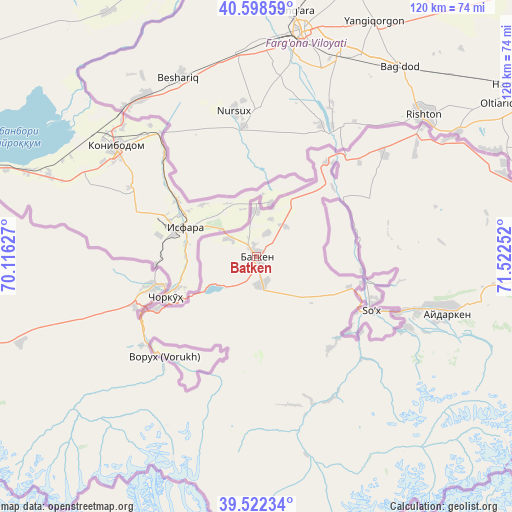
Batken GPS coordinates[2]
40° 3' 45.324" North, 70° 49' 9.804" East
| Map corner | latitude | longitude |
|---|---|---|
| Upper-left | 40.59859°, | 70.11627° |
| Center: | 40.06259°, | 70.81939° |
| Lower-right: | 39.52234°, | 71.52252° |
| Map W x H: | 119.7×119.7 km | = 74.4×74.4mi |
| max Lat: | 42.89106° ⇑77.4% North |
| Batken: | 40.06259° |
| min Lat: | ⇓22.6% South 39.55274° |
| min Long | Batken | max Long |
| 69.3716° | 70.81939° | 78.52702° |
| W 14.3%⇐ | ⇒85.7% E |
Elevation
Elevation of Batken is 1038 m = 3406 ft, and this is 163.4 m = 536 ft below average elevation for this country.
| Max E: |
2638 m = 8655 ft | 53.6% |
| Avg. | 1201.4 m = 3942 ft | |
| Batken | 1038 m = 3406 ft | |
Min E: |
504 m = 1654 ft | 46.4% |
See also: Kyrgyzstan elevation on elevation.city.
Geographical zone
Batken is located in North temperate zone (between Tropic of Cancer and the Arctic Circle). Distance of this Northern Tropic circle is 1848.6 km =1148.7 mi to South.| Distance of | km | miles | from Batken |
|---|---|---|---|
| North Pole | 5552.5 | 3450.2 | to North |
| Arctic Circle | 2946.6 | 1830.9 | to North |
| Tropic Cancer | 1848.6 | 1148.7 | to South |
| Equator | 4454.5 | 2767.9 | to South |


Nearby cities:
15 places around Batken: (largest is in red/bold)
• Ak-Say
32.9 km =20.4 mi,  230°
230°
• Ak-Tatyr
30.7 km =19.1 mi,  248°
248°
• Alga
60.9 km =37.8 mi,  71°
71°
• Aydarken
46.4 km =28.8 mi,  106°
106°
• Boz-Adyr
22.8 km =14.2 mi, 108°
• Chek
5.7 km =3.5 mi,  23°
23°
• Kara-Bak
11 km =6.8 mi,  0°
0°
• Katran
72.8 km =45.2 mi, 250°
• Khalmion
71.1 km =44.2 mi,  76°
76°
• Korgon
77.7 km =48.3 mi,  255°
255°
• Kyrgyz-Kyshtak
52.8 km =32.8 mi,  58°
58°
• Ormosh
39.8 km =24.7 mi, 109°
• Orozbekovo
72.3 km =44.9 mi,  90°
90°
• Samarkandyk
24.4 km =15.2 mi, 252°
• Tayan
30.4 km =18.9 mi,  125°
125°
Sources, notices
• [Note1] Compared only with cities in Kyrgyzstan existing in our database
• [Src1] Map data: © OpenStreetMap contributors (CC-BY-SA)
• [Src2] Other city data from geonames.org with taken over terms of usage.
• [Src3] Geographical zone / Annual Mean Temperature by Robert A. Rohde @ Wikipedia
