Kyrgyz-Kyshtak geodata
Kyrgyz-Kyshtak (Batken) is a seat of a third-order administrative division; located in Kyrgyzstan in Asia/Bishkek (GMT+6) time zone. In our database, there are 37 cities with bigger population. Compared to other cities in Kyrgyzstan, 59.5% of cities are located further ↑North; 76.2% of cities are located further →East and 100% of cities have higher elevation than Kyrgyz-Kyshtak. Note1


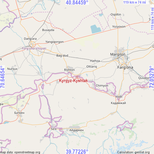
Kyrgyz-Kyshtak GPS coordinates[2]
40° 18' 37.98" North, 71° 20' 58.776" East
| Map corner | latitude | longitude |
|---|---|---|
| Upper-left | 40.84459°, | 70.64654° |
| Center: | 40.31055°, | 71.34966° |
| Lower-right: | 39.77226°, | 72.05279° |
| Map W x H: | 119.2×119.2 km | = 74.1×74.1mi |
| max Lat: | 42.89106° ⇑59.5% North |
| Kyrgyz-Kyshtak: | 40.31055° |
| min Lat: | ⇓40.5% South 39.55274° |
| min Long | Kyrgyz-Kyshtak | max Long |
| 69.3716° | 71.34966° | 78.52702° |
| W 23.8%⇐ | ⇒76.2% E |
Elevation
Elevation of Kyrgyz-Kyshtak is 504 m = 1654 ft, and this is 697.4 m = 2288 ft below average elevation for this country.
| Max E: |
2638 m = 8655 ft | 100% |
| Avg. | 1201.4 m = 3942 ft | |
| Kyrgyz-Kyshtak | 504 m = 1654 ft | |
Min E: |
504 m = 1654 ft | 0% |
See also: Kyrgyzstan elevation on elevation.city.
Geographical zone
Kyrgyz-Kyshtak is located in North temperate zone (between Tropic of Cancer and the Arctic Circle). Distance of this Northern Tropic circle is 1876.2 km =1165.8 mi to South.| Distance of | km | miles | from Kyrgyz-Kyshtak |
|---|---|---|---|
| North Pole | 5524.9 | 3433 | to North |
| Arctic Circle | 2919.1 | 1813.8 | to North |
| Tropic Cancer | 1876.2 | 1165.8 | to South |
| Equator | 4482.1 | 2785 | to South |


Nearby cities:
15 places around Kyrgyz-Kyshtak: (largest is in red/bold)
• Alga
15.1 km =9.4 mi,  123°
123°
• Aydarken
40.9 km =25.4 mi,  180°
180°
• Batken
52.8 km =32.8 mi,  238°
238°
• Boz-Adyr
41.9 km =26 mi,  214°
214°
• Chek
48.2 km =30 mi, 242°
• Kara-Bak
47.9 km =29.8 mi,  249°
249°
• Kara-Dëbë
59.4 km =36.9 mi,  97°
97°
• Khalmion
26.4 km =16.4 mi,  114°
114°
• Kyzyl-Bulak
43.7 km =27.2 mi,  131°
131°
• Markaz
47.3 km =29.4 mi, 99°
• Ormosh
41.2 km =25.6 mi,  190°
190°
• Orozbekovo
39.2 km =24.4 mi,  136°
136°
• Pulgon
37 km =23 mi, 119°
• Tayan
49.8 km =30.9 mi,  204°
204°
• Uch-Korgon
60.9 km =37.8 mi, 98°
Sources, notices
• [Note1] Compared only with cities in Kyrgyzstan existing in our database
• [Src1] Map data: © OpenStreetMap contributors (CC-BY-SA)
• [Src2] Other city data from geonames.org with taken over terms of usage.
• [Src3] Geographical zone / Annual Mean Temperature by Robert A. Rohde @ Wikipedia
