Khalmion geodata
Khalmion (Batken) is a seat of a third-order administrative division; located in Kyrgyzstan in Asia/Bishkek (GMT+6) time zone. In our database, there are 37 cities with bigger population. Compared to other cities in Kyrgyzstan, 70.2% of cities are located further ↑North; 70.2% of cities are located further →East and 82.1% of cities have higher elevation than Khalmion. Note1


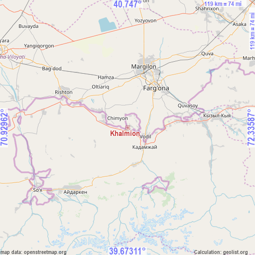
Khalmion GPS coordinates[2]
40° 12' 43.848" North, 71° 37' 57.864" East
| Map corner | latitude | longitude |
|---|---|---|
| Upper-left | 40.747°, | 70.92962° |
| Center: | 40.21218°, | 71.63274° |
| Lower-right: | 39.67311°, | 72.33587° |
| Map W x H: | 119.4×119.4 km | = 74.2×74.2mi |
| max Lat: | 42.89106° ⇑70.2% North |
| Khalmion: | 40.21218° |
| min Lat: | ⇓29.8% South 39.55274° |
| min Long | Khalmion | max Long |
| 69.3716° | 71.63274° | 78.52702° |
| W 29.8%⇐ | ⇒70.2% E |
Elevation
Elevation of Khalmion is 756 m = 2480 ft, and this is 445.4 m = 1461 ft below average elevation for this country.
| Max E: |
2638 m = 8655 ft | 82.1% |
| Avg. | 1201.4 m = 3942 ft | |
| Khalmion | 756 m = 2480 ft | |
Min E: |
504 m = 1654 ft | 17.9% |
See also: Kyrgyzstan elevation on elevation.city.
Geographical zone
Khalmion is located in North temperate zone (between Tropic of Cancer and the Arctic Circle). Distance of this Northern Tropic circle is 1865.3 km =1159 mi to South.| Distance of | km | miles | from Khalmion |
|---|---|---|---|
| North Pole | 5535.9 | 3439.8 | to North |
| Arctic Circle | 2930 | 1820.6 | to North |
| Tropic Cancer | 1865.3 | 1159 | to South |
| Equator | 4471.2 | 2778.3 | to South |


Nearby cities:
15 places around Khalmion: (largest is in red/bold)
• Alga
11.7 km =7.3 mi,  283°
283°
• Aydarken
38.8 km =24.1 mi,  219°
219°
• Boz-Adyr
53.2 km =33.1 mi,  243°
243°
• Iradan
40.1 km =24.9 mi,  81°
81°
• Kara-Dzhygach
40.3 km =25 mi,  104°
104°
• Kara-Dëbë
35.2 km =21.9 mi, 84°
• Karavan
47.9 km =29.8 mi, 78°
• Kyrgyz-Kyshtak
26.4 km =16.4 mi,  294°
294°
• Kyzyl-Bulak
19.9 km =12.4 mi,  153°
153°
• Kyzyl-Kyya
42.3 km =26.3 mi, 83°
• Markaz
22.9 km =14.2 mi, 82°
• Ormosh
43.3 km =26.9 mi,  226°
226°
• Orozbekovo
17.5 km =10.9 mi,  169°
169°
• Pulgon
10.9 km =6.8 mi,  131°
131°
• Uch-Korgon
36.3 km =22.6 mi,  87°
87°
Sources, notices
• [Note1] Compared only with cities in Kyrgyzstan existing in our database
• [Src1] Map data: © OpenStreetMap contributors (CC-BY-SA)
• [Src2] Other city data from geonames.org with taken over terms of usage.
• [Src3] Geographical zone / Annual Mean Temperature by Robert A. Rohde @ Wikipedia
