Srae Ambel geodata
Srae Ambel (Koh Kong) is a seat of a second-order administrative division; located in Cambodia in Asia/Phnom_Penh (GMT+7) time zone. In our database, there are 29 cities with bigger population. Compared to other cities in Cambodia, 83.3% of cities are located further ↑North; 72% of cities are located further →East and 72% of cities have higher elevation than Srae Ambel. Note1


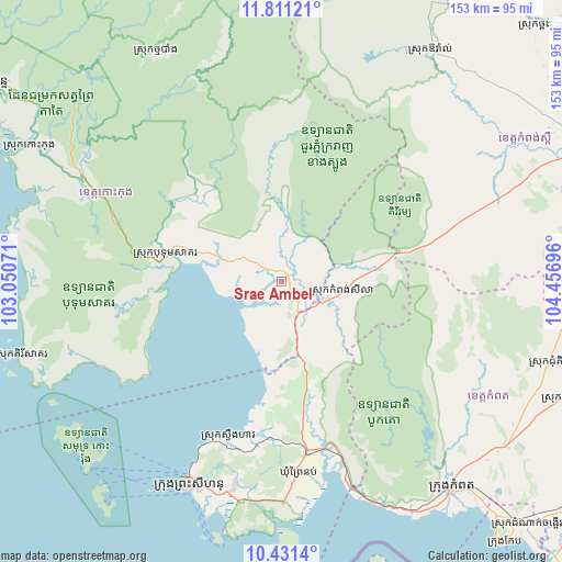
Srae Ambel GPS coordinates[2]
11° 7' 19.632" North, 103° 45' 13.788" East
| Map corner | latitude | longitude |
|---|---|---|
| Upper-left | 11.81121°, | 103.05071° |
| Center: | 11.12212°, | 103.75383° |
| Lower-right: | 10.4314°, | 104.45696° |
| Map W x H: | 153.4×153.4 km | = 95.3×95.3mi |
| max Lat: | 14.23223° ⇑83.3% North |
| Srae Ambel: | 11.12212° |
| min Lat: | ⇓16.7% South 10.48291° |
| min Long | Srae Ambel | max Long |
| 102.37574° | 103.75383° | 107.42393° |
| W 28%⇐ | ⇒72% E |
Elevation
Elevation of Srae Ambel is 16 m = 52 ft, and this is 36 m = 118 ft below average elevation for this country.
| Max E: |
678 m = 2224 ft | 72% |
| Avg. | 52 m = 171 ft | |
| Srae Ambel | 16 m = 52 ft | |
Min E: |
4 m = 13 ft | 28% |
See also: Cambodia elevation on elevation.city.
Geographical zone
Srae Ambel is located in North Torrid zone (between Equator and Tropic of Cancer). Distance of Equator is 1236.7 km =768.4 mi to South.| Distance of | km | miles | from Srae Ambel |
|---|---|---|---|
| North Pole | 8770.4 | 5449.7 | to North |
| Arctic Circle | 6164.5 | 3830.4 | to North |
| Tropic Cancer | 1369.3 | 850.8 | to North |
| Equator | 1236.7 | 768.4 | to South |


Nearby cities:
15 places around Srae Ambel: (largest is in red/bold)
• Aoral
75.1 km =46.7 mi,  33°
33°
• Basedth
85.4 km =53.1 mi,  87°
87°
• Botum Sakor
31.7 km =19.7 mi,  283°
283°
• Chhuk
82.9 km =51.5 mi,  112°
112°
• Chum Kiri
76.1 km =47.3 mi, 106°
• Kampong Seila
16.4 km =10.2 mi,  101°
101°
• Kampong Speu
91.4 km =56.8 mi,  66°
66°
• Kampot
73.6 km =45.7 mi,  140°
140°
• Kampot
79.5 km =49.4 mi, 136°
• Mittakpheap
60.9 km =37.8 mi,  204°
204°
• Phnum Sruoch
73.4 km =45.6 mi, 66°
• Prey Nob
46.5 km =28.9 mi,  170°
170°
• Sihanoukville
62.1 km =38.6 mi, 203°
• Smach Mean Chey
91.4 km =56.8 mi,  301°
301°
• Thma Bang
61.5 km =38.2 mi,  336°
336°
Sources, notices
• [Note1] Compared only with cities in Cambodia existing in our database
• [Src1] Map data: © OpenStreetMap contributors (CC-BY-SA)
• [Src2] Other city data from geonames.org with taken over terms of usage.
• [Src3] Geographical zone / Annual Mean Temperature by Robert A. Rohde @ Wikipedia
