Thma Bang geodata
Thma Bang (Koh Kong) is a seat of a second-order administrative division; located in Cambodia in Asia/Phnom_Penh (GMT+7) time zone. In our database, there are 29 cities with bigger population. Compared to other cities in Cambodia, 62.9% of cities are located further ↑North; 74.2% of cities are located further →East and 93.9% of cities have lower elevation than Thma Bang. Note1


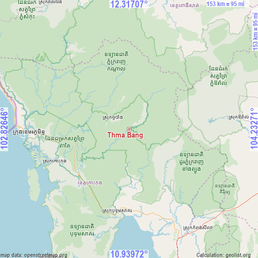
Thma Bang GPS coordinates[2]
11° 37' 45.3" North, 103° 31' 46.488" East
| Map corner | latitude | longitude |
|---|---|---|
| Upper-left | 12.31707°, | 102.82646° |
| Center: | 11.62925°, | 103.52958° |
| Lower-right: | 10.93972°, | 104.23271° |
| Map W x H: | 153.1×153.2 km | = 95.1×95.2mi |
| max Lat: | 14.23223° ⇑62.9% North |
| Thma Bang: | 11.62925° |
| min Lat: | ⇓37.1% South 10.48291° |
| min Long | Thma Bang | max Long |
| 102.37574° | 103.52958° | 107.42393° |
| W 25.8%⇐ | ⇒74.2% E |
Elevation
Elevation of Thma Bang is 188 m = 617 ft, and this is 136 m = 446 ft above average elevation for this country.
| Max E: |
678 m = 2224 ft | 6.1% |
| Thma Bang | 188 m 617 ft | |
| Avg. | 52 m = 171 ft | |
Min E: |
4 m = 13 ft | 93.9% |
See also: Cambodia elevation on elevation.city.
Geographical zone
Thma Bang is located in North Torrid zone (between Equator and Tropic of Cancer). Distance of Equator is 1293.1 km =803.5 mi to South.| Distance of | km | miles | from Thma Bang |
|---|---|---|---|
| North Pole | 8714 | 5414.6 | to North |
| Arctic Circle | 6108.1 | 3795.4 | to North |
| Tropic Cancer | 1312.9 | 815.8 | to North |
| Equator | 1293.1 | 803.5 | to South |


Nearby cities:
15 places around Thma Bang: (largest is in red/bold)
• Aoral
65.7 km =40.8 mi,  84°
84°
• Bak Khlang
62.9 km =39.1 mi,  263°
263°
• Botum Sakor
49.6 km =30.8 mi,  187°
187°
• Kampong Seila
72.2 km =44.9 mi,  145°
145°
• Koh Kong
59.5 km =37 mi,  268°
268°
• Mondul Seima
63.1 km =39.2 mi, 269°
• Phnum Kravanh
84.4 km =52.4 mi,  18°
18°
• Phnum Sruoch
95.7 km =59.5 mi,  106°
106°
• Prey Nob
107.1 km =66.5 mi,  162°
162°
• Pursat
109.6 km =68.1 mi, 22°
• Smach Mean Chey
54.6 km =33.9 mi, 260°
• Smach Meanchey
59 km =36.7 mi, 267°
• Srae Ambel
61.5 km =38.2 mi, 156°
• Thpong
98.7 km =61.3 mi, 81°
• Veal Veaeng
88.3 km =54.9 mi,  328°
328°
Sources, notices
• [Note1] Compared only with cities in Cambodia existing in our database
• [Src1] Map data: © OpenStreetMap contributors (CC-BY-SA)
• [Src2] Other city data from geonames.org with taken over terms of usage.
• [Src3] Geographical zone / Annual Mean Temperature by Robert A. Rohde @ Wikipedia
