Botum Sakor geodata
Botum Sakor (Koh Kong) is a seat of a second-order administrative division; located in Cambodia in Asia/Phnom_Penh (GMT+7) time zone. In our database, there are 29 cities with bigger population. Compared to other cities in Cambodia, 78.8% of cities are located further ↑North; 77.3% of cities are located further →East and 53.8% of cities have higher elevation than Botum Sakor. Note1


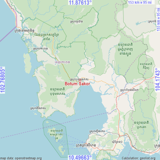
Botum Sakor GPS coordinates[2]
11° 11' 13.92" North, 103° 28' 16.212" East
| Map corner | latitude | longitude |
|---|---|---|
| Upper-left | 11.87613°, | 102.76805° |
| Center: | 11.1872°, | 103.47117° |
| Lower-right: | 10.49663°, | 104.1743° |
| Map W x H: | 153.4×153.4 km | = 95.3×95.3mi |
| max Lat: | 14.23223° ⇑78.8% North |
| Botum Sakor: | 11.1872° |
| min Lat: | ⇓21.2% South 10.48291° |
| min Long | Botum Sakor | max Long |
| 102.37574° | 103.47117° | 107.42393° |
| W 22.7%⇐ | ⇒77.3% E |
Elevation
Elevation of Botum Sakor is 20 m = 66 ft, and this is 32 m = 105 ft below average elevation for this country.
| Max E: |
678 m = 2224 ft | 53.8% |
| Avg. | 52 m = 171 ft | |
| Botum Sakor | 20 m = 66 ft | |
Min E: |
4 m = 13 ft | 46.2% |
See also: Cambodia elevation on elevation.city.
Geographical zone
Botum Sakor is located in North Torrid zone (between Equator and Tropic of Cancer). Distance of Equator is 1243.9 km =772.9 mi to South.| Distance of | km | miles | from Botum Sakor |
|---|---|---|---|
| North Pole | 8763.2 | 5445.2 | to North |
| Arctic Circle | 6157.3 | 3826 | to North |
| Tropic Cancer | 1362 | 846.3 | to North |
| Equator | 1243.9 | 772.9 | to South |


Nearby cities:
15 places around Botum Sakor: (largest is in red/bold)
• Aoral
90.8 km =56.4 mi,  52°
52°
• Bak Khlang
70.4 km =43.7 mi,  307°
307°
• Kampong Seila
48.1 km =29.9 mi,  102°
102°
• Kampot
100.6 km =62.5 mi,  129°
129°
• Kampot
107.5 km =66.8 mi, 127°
• Koh Kong
71.3 km =44.3 mi, 311°
• Mittakpheap
63 km =39.1 mi,  174°
174°
• Mondul Seima
74.7 km =46.4 mi, 310°
• Phnum Sruoch
100.6 km =62.5 mi,  77°
77°
• Prey Nob
65.4 km =40.6 mi,  144°
144°
• Sihanoukville
64.6 km =40.1 mi, 174°
• Smach Mean Chey
62.1 km =38.6 mi, 310°
• Smach Meanchey
70.2 km =43.6 mi, 311°
• Srae Ambel
31.7 km =19.7 mi, 103°
• Thma Bang
49.6 km =30.8 mi,  7°
7°
Sources, notices
• [Note1] Compared only with cities in Cambodia existing in our database
• [Src1] Map data: © OpenStreetMap contributors (CC-BY-SA)
• [Src2] Other city data from geonames.org with taken over terms of usage.
• [Src3] Geographical zone / Annual Mean Temperature by Robert A. Rohde @ Wikipedia
