Pursat geodata
Pursat is a seat of a first-order administrative division; located in Cambodia in Asia/Phnom_Penh (GMT+7) time zone. With population of 52,476 people, there are 8 cities with bigger population in this country. Compared to other cities in Cambodia, 57.6% of cities are located further ↓South; 65.9% of cities are located further →East and 58.3% of cities have lower elevation than Pursat. Note1


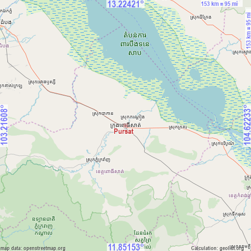
Pursat GPS coordinates[2]
12° 32' 19.608" North, 103° 55' 9.12" East
| Map corner | latitude | longitude |
|---|---|---|
| Upper-left | 13.22421°, | 103.21608° |
| Center: | 12.53878°, | 103.9192° |
| Lower-right: | 11.85153°, | 104.62233° |
| Map W x H: | 152.6×152.6 km | = 94.8×94.8mi |
| max Lat: | 14.23223° ⇑42.4% North |
| Pursat: | 12.53878° |
| min Lat: | ⇓57.6% South 10.48291° |
| min Long | Pursat | max Long |
| 102.37574° | 103.9192° | 107.42393° |
| W 34.1%⇐ | ⇒65.9% E |
Elevation
Elevation of Pursat is 25 m = 82 ft, and this is 27 m = 89 ft below average elevation for this country.
| Max E: |
678 m = 2224 ft | 41.7% |
| Avg. | 52 m = 171 ft | |
| Pursat | 25 m = 82 ft | |
Min E: |
4 m = 13 ft | 58.3% |
See also: Pursat elevation on elevation.city.
Geographical zone
Pursat is located in North Torrid zone (between Equator and Tropic of Cancer). Distance of this Northern Tropic circle is 1211.7 km =752.9 mi to North.| Distance of | km | miles | from Pursat |
|---|---|---|---|
| North Pole | 8612.9 | 5351.8 | to North |
| Arctic Circle | 6007 | 3732.6 | to North |
| Tropic Cancer | 1211.7 | 752.9 | to North |
| Equator | 1394.2 | 866.3 | to South |


Nearby cities:
15 places around Pursat: (largest is in red/bold)
• Bakan
16.1 km =10 mi,  295°
295°
• Bakong
90.2 km =56 mi,  4°
4°
• Baribour
60.1 km =37.3 mi,  100°
100°
• Chi Kraeng
79.7 km =49.5 mi,  35°
35°
• Kampong Chhnang
87.3 km =54.2 mi,  111°
111°
• Kampong Leaeng
92.6 km =57.5 mi, 108°
• Koas Krala
76 km =47.2 mi,  288°
288°
• Moung Ruessei
57.3 km =35.6 mi, 297°
• Phnum Kravanh
26.4 km =16.4 mi,  217°
217°
• Sangkae
94.7 km =58.8 mi,  309°
309°
• Siem Reap
91.7 km =57 mi,  356°
356°
• Soutr Nikom
81.4 km =50.6 mi,  16°
16°
• Stoung
83.6 km =51.9 mi,  57°
57°
• Ta Loas
58.1 km =36.1 mi, 301°
• Veal Veaeng
92.4 km =57.4 mi,  253°
253°
Sources, notices
• [Note1] Compared only with cities in Cambodia existing in our database
• [Src1] Map data: © OpenStreetMap contributors (CC-BY-SA)
• [Src2] Other city data from geonames.org with taken over terms of usage.
• [Src3] Geographical zone / Annual Mean Temperature by Robert A. Rohde @ Wikipedia
