Veal Veaeng geodata
Veal Veaeng (Pursat) is a seat of a second-order administrative division; located in Cambodia in Asia/Phnom_Penh (GMT+7) time zone. In our database, there are 29 cities with bigger population. Compared to other cities in Cambodia, 51.5% of cities are located further ↓South; 85.6% of cities are located further →East and 96.2% of cities have lower elevation than Veal Veaeng. Note1


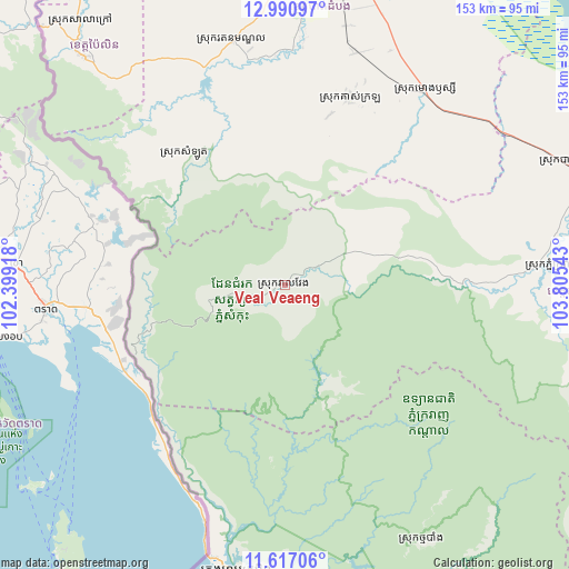
Veal Veaeng GPS coordinates[2]
12° 18' 17.676" North, 103° 6' 8.28" East
| Map corner | latitude | longitude |
|---|---|---|
| Upper-left | 12.99097°, | 102.39918° |
| Center: | 12.30491°, | 103.1023° |
| Lower-right: | 11.61706°, | 103.80543° |
| Map W x H: | 152.8×152.8 km | = 94.9×94.9mi |
| max Lat: | 14.23223° ⇑48.5% North |
| Veal Veaeng: | 12.30491° |
| min Lat: | ⇓51.5% South 10.48291° |
| min Long | Veal Veaeng | max Long |
| 102.37574° | 103.1023° | 107.42393° |
| W 14.4%⇐ | ⇒85.6% E |
Elevation
Elevation of Veal Veaeng is 242 m = 794 ft, and this is 190 m = 623 ft above average elevation for this country.
| Max E: |
678 m = 2224 ft | 3.8% |
| Veal Veaeng | 242 m 794 ft | |
| Avg. | 52 m = 171 ft | |
Min E: |
4 m = 13 ft | 96.2% |
See also: Cambodia elevation on elevation.city.
Geographical zone
Veal Veaeng is located in North Torrid zone (between Equator and Tropic of Cancer). Distance of this Northern Tropic circle is 1237.7 km =769.1 mi to North.| Distance of | km | miles | from Veal Veaeng |
|---|---|---|---|
| North Pole | 8638.9 | 5368 | to North |
| Arctic Circle | 6033 | 3748.7 | to North |
| Tropic Cancer | 1237.7 | 769.1 | to North |
| Equator | 1368.2 | 850.2 | to South |


Nearby cities:
15 places around Veal Veaeng: (largest is in red/bold)
• Bak Khlang
83.4 km =51.8 mi,  191°
191°
• Bakan
81.2 km =50.5 mi,  65°
65°
• Banan
70.7 km =43.9 mi,  3°
3°
• Koas Krala
52.8 km =32.8 mi,  18°
18°
• Koh Kong
77.8 km =48.3 mi, 189°
• Mondul Seima
77.5 km =48.2 mi, 192°
• Moung Ruessei
64.4 km =40 mi,  35°
35°
• Pailin
80.8 km =50.2 mi,  318°
318°
• Phnum Kravanh
72.6 km =45.1 mi,  85°
85°
• Samlout
43.6 km =27.1 mi, 322°
• Sangkae
87.5 km =54.4 mi,  10°
10°
• Smach Mean Chey
84.6 km =52.6 mi,  184°
184°
• Smach Meanchey
78.9 km =49 mi, 189°
• Ta Loas
68.1 km =42.3 mi,  34°
34°
• Thma Bang
88.3 km =54.9 mi,  148°
148°
Sources, notices
• [Note1] Compared only with cities in Cambodia existing in our database
• [Src1] Map data: © OpenStreetMap contributors (CC-BY-SA)
• [Src2] Other city data from geonames.org with taken over terms of usage.
• [Src3] Geographical zone / Annual Mean Temperature by Robert A. Rohde @ Wikipedia
