Kampong Leaeng geodata
Kampong Leaeng (Kampong Chhnang) is a seat of a second-order administrative division; located in Cambodia in Asia/Phnom_Penh (GMT+7) time zone. In our database, there are 29 cities with bigger population. Compared to other cities in Cambodia, 50.8% of cities are located further ↓South; 53% of cities are located further ←West and 72% of cities have higher elevation than Kampong Leaeng. Note1


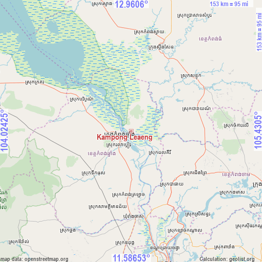
Kampong Leaeng GPS coordinates[2]
12° 16' 28.056" North, 104° 43' 38.532" East
| Map corner | latitude | longitude |
|---|---|---|
| Upper-left | 12.9606°, | 104.02425° |
| Center: | 12.27446°, | 104.72737° |
| Lower-right: | 11.58653°, | 105.4305° |
| Map W x H: | 152.8×152.8 km | = 94.9×94.9mi |
| max Lat: | 14.23223° ⇑49.2% North |
| Kampong Leaeng: | 12.27446° |
| min Lat: | ⇓50.8% South 10.48291° |
| min Long | Kampong Leaeng | max Long |
| 102.37574° | 104.72737° | 107.42393° |
| W 53%⇐ | ⇒47% E |
Elevation
Elevation of Kampong Leaeng is 16 m = 52 ft, and this is 36 m = 118 ft below average elevation for this country.
| Max E: |
678 m = 2224 ft | 72% |
| Avg. | 52 m = 171 ft | |
| Kampong Leaeng | 16 m = 52 ft | |
Min E: |
4 m = 13 ft | 28% |
See also: Cambodia elevation on elevation.city.
Geographical zone
Kampong Leaeng is located in North Torrid zone (between Equator and Tropic of Cancer). Distance of this Northern Tropic circle is 1241.1 km =771.2 mi to North.| Distance of | km | miles | from Kampong Leaeng |
|---|---|---|---|
| North Pole | 8642.3 | 5370.1 | to North |
| Arctic Circle | 6036.4 | 3750.8 | to North |
| Tropic Cancer | 1241.1 | 771.2 | to North |
| Equator | 1364.8 | 848 | to South |


Nearby cities:
15 places around Kampong Leaeng: (largest is in red/bold)
• Baray
40.1 km =24.9 mi,  70°
70°
• Baribour
34 km =21.1 mi,  302°
302°
• Batheay
39.4 km =24.5 mi,  143°
143°
• Chamkar Leu
60.4 km =37.5 mi,  86°
86°
• Cheung Prey
44.8 km =27.8 mi,  122°
122°
• Kampong Chhnang
7.1 km =4.4 mi,  247°
247°
• Kampong Thom
51.6 km =32.1 mi,  19°
19°
• Kang Meas
69.8 km =43.4 mi, 121°
• Mukh Kampul
65.8 km =40.9 mi,  155°
155°
• Odongk
65.9 km =40.9 mi,  182°
182°
• Ponhea Lueu
70.4 km =43.7 mi,  167°
167°
• Prey Chhor
62.4 km =38.8 mi,  112°
112°
• Ruessei Kaev
74.9 km =46.5 mi, 164°
• Stueng Saen
51.7 km =32.1 mi, 20°
• Thpong
66.5 km =41.3 mi,  209°
209°
Sources, notices
• [Note1] Compared only with cities in Cambodia existing in our database
• [Src1] Map data: © OpenStreetMap contributors (CC-BY-SA)
• [Src2] Other city data from geonames.org with taken over terms of usage.
• [Src3] Geographical zone / Annual Mean Temperature by Robert A. Rohde @ Wikipedia
