Paoy Paet geodata
Paoy Paet (Banteay Meanchey) is a populated place; located in Cambodia in Asia/Phnom_Penh (GMT+7) time zone. With population of 79,000 people, there are 5 cities with bigger population in this country. Compared to other cities in Cambodia, 85.6% of cities are located further ↓South; 97.7% of cities are located further →East and 72% of cities have lower elevation than Paoy Paet. Note1


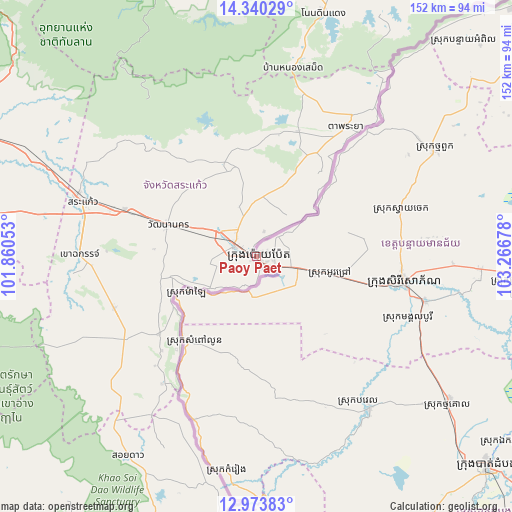
Paoy Paet GPS coordinates[2]
13° 39' 28.98" North, 102° 33' 49.14" East
| Map corner | latitude | longitude |
|---|---|---|
| Upper-left | 14.34029°, | 101.86053° |
| Center: | 13.65805°, | 102.56365° |
| Lower-right: | 12.97383°, | 103.26678° |
| Map W x H: | 151.9×151.9 km | = 94.4×94.4mi |
| max Lat: | 14.23223° ⇑14.4% North |
| Paoy Paet: | 13.65805° |
| min Lat: | ⇓85.6% South 10.48291° |
| min Long | Paoy Paet | max Long |
| 102.37574° | 102.56365° | 107.42393° |
| W 2.3%⇐ | ⇒97.7% E |
Elevation
Elevation of Paoy Paet is 43 m = 141 ft, and this is 9 m = 30 ft below average elevation for this country.
| Max E: |
678 m = 2224 ft | 28% |
| Avg. | 52 m = 171 ft | |
| Paoy Paet | 43 m = 141 ft | |
Min E: |
4 m = 13 ft | 72% |
See also: Paoy Paet elevation on elevation.city.
Geographical zone
Paoy Paet is located in North Torrid zone (between Equator and Tropic of Cancer). Distance of this Northern Tropic circle is 1087.3 km =675.6 mi to North.| Distance of | km | miles | from Paoy Paet |
|---|---|---|---|
| North Pole | 8488.4 | 5274.4 | to North |
| Arctic Circle | 5882.5 | 3655.2 | to North |
| Tropic Cancer | 1087.3 | 675.6 | to North |
| Equator | 1518.6 | 943.6 | to South |


Nearby cities:
15 places around Paoy Paet: (largest is in red/bold)
• Aek Phnum
91 km =56.5 mi,  127°
127°
• Bat Dambang
71.9 km =44.7 mi, 127°
• Bavel
56.6 km =35.2 mi,  143°
143°
• Kamrieng
63.9 km =39.7 mi,  187°
187°
• Mongkol Borei
51.7 km =32.1 mi,  104°
104°
• Ou Chrov
3 km =1.9 mi, 134°
• Pailin
90.1 km =56 mi,  176°
176°
• Phnum Proek
51.6 km =32.1 mi,  200°
200°
• Phnum Srok
84.3 km =52.4 mi,  83°
83°
• Preah Netr Preah
66.9 km =41.6 mi,  93°
93°
• Sala Krau
78.2 km =48.6 mi, 176°
• Sampov Lun
32.3 km =20.1 mi,  218°
218°
• Sisophon
45 km =28 mi, 100°
• Svay Chek
46 km =28.6 mi,  69°
69°
• Thma Puok
61.4 km =38.2 mi,  59°
59°
Sources, notices
• [Note1] Compared only with cities in Cambodia existing in our database
• [Src1] Map data: © OpenStreetMap contributors (CC-BY-SA)
• [Src2] Other city data from geonames.org with taken over terms of usage.
• [Src3] Geographical zone / Annual Mean Temperature by Robert A. Rohde @ Wikipedia
