Phnum Srok geodata
Phnum Srok (Banteay Meanchey) is a seat of a second-order administrative division; located in Cambodia in Asia/Phnom_Penh (GMT+7) time zone. In our database, there are 29 cities with bigger population. Compared to other cities in Cambodia, 89.4% of cities are located further ↓South; 80.3% of cities are located further →East and 53.8% of cities have lower elevation than Phnum Srok. Note1


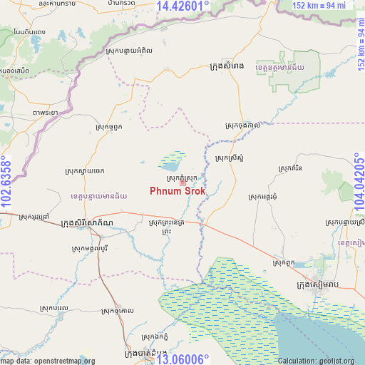
Phnum Srok GPS coordinates[2]
13° 44' 38.508" North, 103° 20' 20.112" East
| Map corner | latitude | longitude |
|---|---|---|
| Upper-left | 14.42601°, | 102.6358° |
| Center: | 13.74403°, | 103.33892° |
| Lower-right: | 13.06006°, | 104.04205° |
| Map W x H: | 151.9×151.9 km | = 94.4×94.4mi |
| max Lat: | 14.23223° ⇑10.6% North |
| Phnum Srok: | 13.74403° |
| min Lat: | ⇓89.4% South 10.48291° |
| min Long | Phnum Srok | max Long |
| 102.37574° | 103.33892° | 107.42393° |
| W 19.7%⇐ | ⇒80.3% E |
Elevation
Elevation of Phnum Srok is 23 m = 75 ft, and this is 29 m = 95 ft below average elevation for this country.
| Max E: |
678 m = 2224 ft | 46.2% |
| Avg. | 52 m = 171 ft | |
| Phnum Srok | 23 m = 75 ft | |
Min E: |
4 m = 13 ft | 53.8% |
See also: Cambodia elevation on elevation.city.
Geographical zone
Phnum Srok is located in North Torrid zone (between Equator and Tropic of Cancer). Distance of this Northern Tropic circle is 1077.7 km =669.7 mi to North.| Distance of | km | miles | from Phnum Srok |
|---|---|---|---|
| North Pole | 8478.9 | 5268.5 | to North |
| Arctic Circle | 5873 | 3649.3 | to North |
| Tropic Cancer | 1077.7 | 669.7 | to North |
| Equator | 1528.2 | 949.6 | to South |


Nearby cities:
15 places around Phnum Srok: (largest is in red/bold)
• Aek Phnum
66 km =41 mi,  190°
190°
• Angkor Chum
34 km =21.1 mi,  101°
101°
• Angkor Thum
64.7 km =40.2 mi,  116°
116°
• Bat Dambang
59.9 km =37.2 mi,  206°
206°
• Battambang
72.9 km =45.3 mi, 192°
• Kralanh
17.7 km =11 mi,  150°
150°
• Mongkol Borei
40.6 km =25.2 mi,  236°
236°
• Preah Netr Preah
21.6 km =13.4 mi,  231°
231°
• Samraong
52.4 km =32.6 mi,  21°
21°
• Siem Reap
70.6 km =43.9 mi,  127°
127°
• Sisophon
43.2 km =26.8 mi,  245°
245°
• Srei Snam
21.3 km =13.2 mi,  61°
61°
• Svay Chek
41.3 km =25.7 mi,  279°
279°
• Thma Puok
37.8 km =23.5 mi,  305°
305°
• Varin
45.9 km =28.5 mi,  83°
83°
Sources, notices
• [Note1] Compared only with cities in Cambodia existing in our database
• [Src1] Map data: © OpenStreetMap contributors (CC-BY-SA)
• [Src2] Other city data from geonames.org with taken over terms of usage.
• [Src3] Geographical zone / Annual Mean Temperature by Robert A. Rohde @ Wikipedia
