Mongkol Borei geodata
Mongkol Borei (Banteay Meanchey) is a seat of a second-order administrative division; located in Cambodia in Asia/Phnom_Penh (GMT+7) time zone. In our database, there are 29 cities with bigger population. Compared to other cities in Cambodia, 79.5% of cities are located further ↓South; 88.6% of cities are located further →East and 72% of cities have higher elevation than Mongkol Borei. Note1


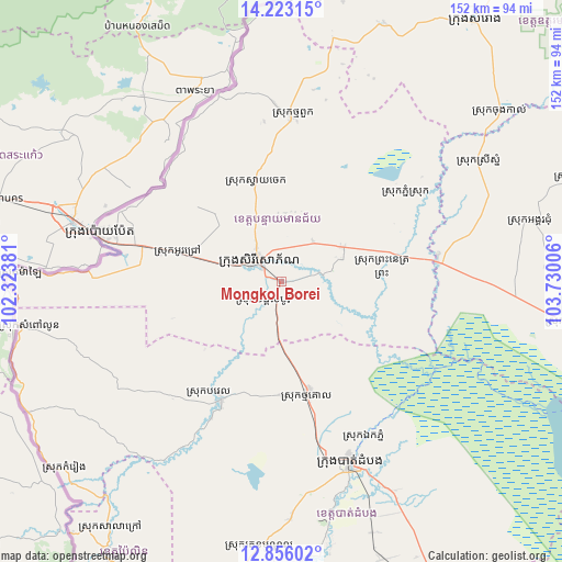
Mongkol Borei GPS coordinates[2]
13° 32' 26.052" North, 103° 1' 36.948" East
| Map corner | latitude | longitude |
|---|---|---|
| Upper-left | 14.22315°, | 102.32381° |
| Center: | 13.54057°, | 103.02693° |
| Lower-right: | 12.85602°, | 103.73006° |
| Map W x H: | 152×152 km | = 94.4×94.4mi |
| max Lat: | 14.23223° ⇑20.5% North |
| Mongkol Borei: | 13.54057° |
| min Lat: | ⇓79.5% South 10.48291° |
| min Long | Mongkol Borei | max Long |
| 102.37574° | 103.02693° | 107.42393° |
| W 11.4%⇐ | ⇒88.6% E |
Elevation
Elevation of Mongkol Borei is 16 m = 52 ft, and this is 36 m = 118 ft below average elevation for this country.
| Max E: |
678 m = 2224 ft | 72% |
| Avg. | 52 m = 171 ft | |
| Mongkol Borei | 16 m = 52 ft | |
Min E: |
4 m = 13 ft | 28% |
See also: Cambodia elevation on elevation.city.
Geographical zone
Mongkol Borei is located in North Torrid zone (between Equator and Tropic of Cancer). Distance of this Northern Tropic circle is 1100.3 km =683.7 mi to North.| Distance of | km | miles | from Mongkol Borei |
|---|---|---|---|
| North Pole | 8501.5 | 5282.6 | to North |
| Arctic Circle | 5895.6 | 3663.4 | to North |
| Tropic Cancer | 1100.3 | 683.7 | to North |
| Equator | 1505.6 | 935.5 | to South |


Nearby cities:
15 places around Mongkol Borei: (largest is in red/bold)
• Aek Phnum
47.8 km =29.7 mi,  152°
152°
• Banan
68 km =42.3 mi,  169°
169°
• Bat Dambang
31.6 km =19.6 mi, 167°
• Battambang
52.1 km =32.4 mi,  159°
159°
• Bavel
36 km =22.4 mi,  206°
206°
• Kralanh
43 km =26.7 mi,  80°
80°
• Ou Chrov
49.1 km =30.5 mi,  282°
282°
• Paoy Paet
51.7 km =32.1 mi, 284°
• Phnum Srok
40.6 km =25.2 mi,  56°
56°
• Preah Netr Preah
19.2 km =11.9 mi, 61°
• Sangkae
56.4 km =35 mi, 155°
• Sisophon
7.6 km =4.7 mi,  311°
311°
• Srei Snam
61.8 km =38.4 mi, 58°
• Svay Chek
30.3 km =18.8 mi,  346°
346°
• Thma Puok
44.5 km =27.7 mi,  3°
3°
Sources, notices
• [Note1] Compared only with cities in Cambodia existing in our database
• [Src1] Map data: © OpenStreetMap contributors (CC-BY-SA)
• [Src2] Other city data from geonames.org with taken over terms of usage.
• [Src3] Geographical zone / Annual Mean Temperature by Robert A. Rohde @ Wikipedia
