Kralanh geodata
Kralanh (Siem Reap) is a seat of a second-order administrative division; located in Cambodia in Asia/Phnom_Penh (GMT+7) time zone. In our database, there are 29 cities with bigger population. Compared to other cities in Cambodia, 83.3% of cities are located further ↓South; 79.5% of cities are located further →East and 50.8% of cities have higher elevation than Kralanh. Note1


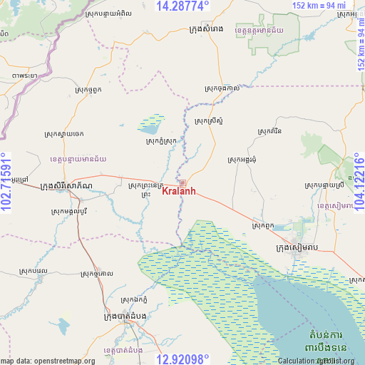
Kralanh GPS coordinates[2]
13° 36' 19.26" North, 103° 25' 8.508" East
| Map corner | latitude | longitude |
|---|---|---|
| Upper-left | 14.28774°, | 102.71591° |
| Center: | 13.60535°, | 103.41903° |
| Lower-right: | 12.92098°, | 104.12216° |
| Map W x H: | 152×152 km | = 94.4×94.4mi |
| max Lat: | 14.23223° ⇑16.7% North |
| Kralanh: | 13.60535° |
| min Lat: | ⇓83.3% South 10.48291° |
| min Long | Kralanh | max Long |
| 102.37574° | 103.41903° | 107.42393° |
| W 20.5%⇐ | ⇒79.5% E |
Elevation
Elevation of Kralanh is 21 m = 69 ft, and this is 31 m = 102 ft below average elevation for this country.
| Max E: |
678 m = 2224 ft | 50.8% |
| Avg. | 52 m = 171 ft | |
| Kralanh | 21 m = 69 ft | |
Min E: |
4 m = 13 ft | 49.2% |
See also: Cambodia elevation on elevation.city.
Geographical zone
Kralanh is located in North Torrid zone (between Equator and Tropic of Cancer). Distance of this Northern Tropic circle is 1093.1 km =679.2 mi to North.| Distance of | km | miles | from Kralanh |
|---|---|---|---|
| North Pole | 8494.3 | 5278.1 | to North |
| Arctic Circle | 5888.4 | 3658.9 | to North |
| Tropic Cancer | 1093.1 | 679.2 | to North |
| Equator | 1512.8 | 940 | to South |


Nearby cities:
15 places around Kralanh: (largest is in red/bold)
• Aek Phnum
53.5 km =33.2 mi,  202°
202°
• Angkor Chum
26.2 km =16.3 mi,  70°
70°
• Angkor Thum
51 km =31.7 mi,  105°
105°
• Bat Dambang
52.1 km =32.4 mi,  223°
223°
• Battambang
60.8 km =37.8 mi, 203°
• Mongkol Borei
43 km =26.7 mi,  260°
260°
• Phnum Srok
17.7 km =11 mi,  330°
330°
• Preah Netr Preah
25.7 km =16 mi,  274°
274°
• Sangkae
61.4 km =38.2 mi, 197°
• Siem Reap
54.9 km =34.1 mi,  119°
119°
• Sisophon
48.2 km =30 mi, 267°
• Srei Snam
27.4 km =17 mi,  21°
21°
• Svay Chek
54.2 km =33.7 mi,  294°
294°
• Thma Puok
54.3 km =33.7 mi,  313°
313°
• Varin
42.4 km =26.3 mi,  60°
60°
Sources, notices
• [Note1] Compared only with cities in Cambodia existing in our database
• [Src1] Map data: © OpenStreetMap contributors (CC-BY-SA)
• [Src2] Other city data from geonames.org with taken over terms of usage.
• [Src3] Geographical zone / Annual Mean Temperature by Robert A. Rohde @ Wikipedia
