Angkor Chum geodata
Angkor Chum (Siem Reap) is a seat of a second-order administrative division; located in Cambodia in Asia/Phnom_Penh (GMT+7) time zone. In our database, there are 29 cities with bigger population. Compared to other cities in Cambodia, 87.1% of cities are located further ↓South; 72.7% of cities are located further →East and 62.9% of cities have lower elevation than Angkor Chum. Note1


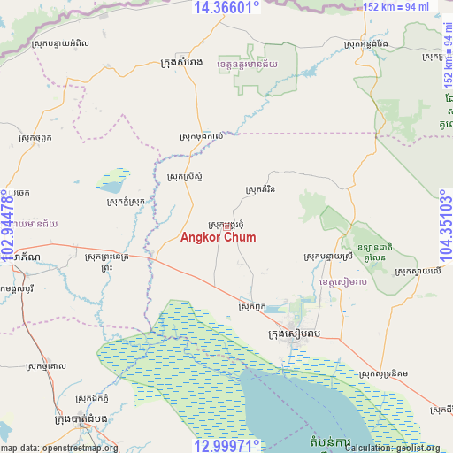
Angkor Chum GPS coordinates[2]
13° 41' 1.86" North, 103° 38' 52.44" East
| Map corner | latitude | longitude |
|---|---|---|
| Upper-left | 14.36601°, | 102.94478° |
| Center: | 13.68385°, | 103.6479° |
| Lower-right: | 12.99971°, | 104.35103° |
| Map W x H: | 151.9×151.9 km | = 94.4×94.4mi |
| max Lat: | 14.23223° ⇑12.9% North |
| Angkor Chum: | 13.68385° |
| min Lat: | ⇓87.1% South 10.48291° |
| min Long | Angkor Chum | max Long |
| 102.37574° | 103.6479° | 107.42393° |
| W 27.3%⇐ | ⇒72.7% E |
Elevation
Elevation of Angkor Chum is 28 m = 92 ft, and this is 24 m = 79 ft below average elevation for this country.
| Max E: |
678 m = 2224 ft | 37.1% |
| Avg. | 52 m = 171 ft | |
| Angkor Chum | 28 m = 92 ft | |
Min E: |
4 m = 13 ft | 62.9% |
See also: Cambodia elevation on elevation.city.
Geographical zone
Angkor Chum is located in North Torrid zone (between Equator and Tropic of Cancer). Distance of this Northern Tropic circle is 1084.4 km =673.8 mi to North.| Distance of | km | miles | from Angkor Chum |
|---|---|---|---|
| North Pole | 8485.6 | 5272.7 | to North |
| Arctic Circle | 5879.7 | 3653.5 | to North |
| Tropic Cancer | 1084.4 | 673.8 | to North |
| Equator | 1521.5 | 945.4 | to South |


Nearby cities:
15 places around Angkor Chum: (largest is in red/bold)
• Aek Phnum
73.6 km =45.7 mi,  217°
217°
• Angkor Thum
33.1 km =20.6 mi,  132°
132°
• Bakong
52.4 km =32.6 mi,  135°
135°
• Kralanh
26.2 km =16.3 mi,  250°
250°
• Mongkol Borei
69 km =42.9 mi,  256°
256°
• Phnum Srok
34 km =21.1 mi,  281°
281°
• Preah Netr Preah
50.8 km =31.6 mi, 262°
• Samraong
57.1 km =35.5 mi,  345°
345°
• Siem Reap
42.6 km =26.5 mi,  147°
147°
• Sisophon
73.7 km =45.8 mi, 261°
• Soutr Nikom
72.5 km =45 mi, 133°
• Srei Snam
22.2 km =13.8 mi,  318°
318°
• Svay Chek
75.3 km =46.8 mi, 280°
• Thma Puok
70.3 km =43.7 mi,  293°
293°
• Varin
17.2 km =10.7 mi,  45°
45°
Sources, notices
• [Note1] Compared only with cities in Cambodia existing in our database
• [Src1] Map data: © OpenStreetMap contributors (CC-BY-SA)
• [Src2] Other city data from geonames.org with taken over terms of usage.
• [Src3] Geographical zone / Annual Mean Temperature by Robert A. Rohde @ Wikipedia
