Cheung Prey geodata
Cheung Prey (Kampong Cham) is a seat of a second-order administrative division; located in Cambodia in Asia/Phnom_Penh (GMT+7) time zone. In our database, there are 29 cities with bigger population. Compared to other cities in Cambodia, 53.8% of cities are located further ↑North; 69.7% of cities are located further ←West and 65.2% of cities have higher elevation than Cheung Prey. Note1


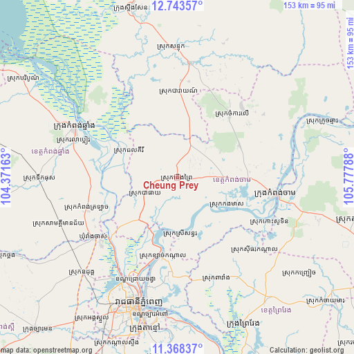
Cheung Prey GPS coordinates[2]
12° 3' 24.66" North, 105° 4' 29.1" East
| Map corner | latitude | longitude |
|---|---|---|
| Upper-left | 12.74357°, | 104.37163° |
| Center: | 12.05685°, | 105.07475° |
| Lower-right: | 11.36837°, | 105.77788° |
| Map W x H: | 152.9×152.9 km | = 95×95mi |
| max Lat: | 14.23223° ⇑53.8% North |
| Cheung Prey: | 12.05685° |
| min Lat: | ⇓46.2% South 10.48291° |
| min Long | Cheung Prey | max Long |
| 102.37574° | 105.07475° | 107.42393° |
| W 69.7%⇐ | ⇒30.3% E |
Elevation
Elevation of Cheung Prey is 17 m = 56 ft, and this is 35 m = 115 ft below average elevation for this country.
| Max E: |
678 m = 2224 ft | 65.2% |
| Avg. | 52 m = 171 ft | |
| Cheung Prey | 17 m = 56 ft | |
Min E: |
4 m = 13 ft | 34.8% |
See also: Cambodia elevation on elevation.city.
Geographical zone
Cheung Prey is located in North Torrid zone (between Equator and Tropic of Cancer). Distance of this Northern Tropic circle is 1265.3 km =786.2 mi to North.| Distance of | km | miles | from Cheung Prey |
|---|---|---|---|
| North Pole | 8666.5 | 5385.1 | to North |
| Arctic Circle | 6060.6 | 3765.9 | to North |
| Tropic Cancer | 1265.3 | 786.2 | to North |
| Equator | 1340.6 | 833 | to South |


Nearby cities:
15 places around Cheung Prey: (largest is in red/bold)
• Baray
37.5 km =23.3 mi,  0°
0°
• Batheay
16.3 km =10.1 mi,  242°
242°
• Chamkar Leu
35.9 km =22.3 mi,  38°
38°
• Kampong Cham
42.9 km =26.7 mi,  99°
99°
• Kampong Chhnang
49.3 km =30.6 mi,  295°
295°
• Kampong Leaeng
44.8 km =27.8 mi, 302°
• Kang Meas
25 km =15.5 mi,  119°
119°
• Kaoh Soutin
42.9 km =26.7 mi, 116°
• Mukh Kampul
37.2 km =23.1 mi,  196°
196°
• Phnom Penh
57.6 km =35.8 mi, 197°
• Ponhea Lueu
50 km =31.1 mi,  206°
206°
• Prey Chhor
19.8 km =12.3 mi,  89°
89°
• Ruessei Kaev
51.3 km =31.9 mi, 200°
• Sithor Kandal
46.1 km =28.6 mi,  133°
133°
• Stueng Trang
54.7 km =34 mi,  66°
66°
Sources, notices
• [Note1] Compared only with cities in Cambodia existing in our database
• [Src1] Map data: © OpenStreetMap contributors (CC-BY-SA)
• [Src2] Other city data from geonames.org with taken over terms of usage.
• [Src3] Geographical zone / Annual Mean Temperature by Robert A. Rohde @ Wikipedia
