Mtsamdou geodata
Mtsamdou (Grande Comore) is a populated place; located in Comoros in Indian/Comoro (GMT+3) time zone. With population of 1,171 people, there are 80 cities with bigger population in this country. Compared to other cities in Comoros, 81.4% of cities are located further ↓South; 64.6% of cities are located further →East and 51.3% of cities have lower elevation than Mtsamdou. Note1


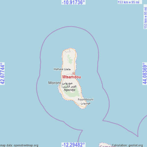
Mtsamdou GPS coordinates[2]
11° 36' 24.984" South, 43° 22' 50.016" East
| Map corner | latitude | longitude |
|---|---|---|
| Upper-left | -10.91736°, | 42.67744° |
| Center: | -11.60694°, | 43.38056° |
| Lower-right: | -12.29482°, | 44.08369° |
| Map W x H: | 153.2×153.2 km | = 95.2×95.2mi |
| max Lat: | -11.38472° ⇑18.6% North |
| Mtsamdou: | -11.60694° |
| min Lat: | ⇓81.4% South -12.37306° |
| min Long | Mtsamdou | max Long |
| 43.2525° | 43.38056° | 44.53194° |
| W 35.4%⇐ | ⇒64.6% E |
Elevation
Elevation of Mtsamdou is 147 m = 482 ft, and this is 49.1 m = 161 ft below average elevation for this country.
| Max E: |
924 m = 3031 ft | 48.7% |
| Avg. | 196.1 m = 643 ft | |
| Mtsamdou | 147 m = 482 ft | |
Min E: |
1 m = 3 ft | 51.3% |
See also: Comoros elevation on elevation.city.
Geographical zone
Mtsamdou is located in South Torrid zone (between Equator and Tropic of Capricorn). Distance of Equator is 1290.6 km =801.9 mi to North.| Distance of | km | miles | from Mtsamdou |
|---|---|---|---|
| Equator | 1290.6 | 801.9 | to North |
| Tropic Capricorn | 1315.3 | 817.3 | to South |
| Antarctic Circle | 6110.6 | 3796.9 | to South |
| South Pole | 8716.5 | 5416.2 | to South |


Nearby cities:
15 places around Mtsamdou: (largest is in red/bold)
• Bahani
11.1 km =6.9 mi,  250°
250°
• Batou
12.3 km =7.6 mi,  348°
348°
• Bibavou
11.9 km =7.4 mi,  288°
288°
• Chomoni
4.1 km =2.5 mi,  171°
171°
• Dzahani
12.7 km =7.9 mi,  243°
243°
• Héroumbili
7 km =4.3 mi,  359°
359°
• Mbéni
11.7 km =7.3 mi, 358°
• Milévani
11.6 km =7.2 mi,  302°
302°
• Mnoungou
9.9 km =6.2 mi, 355°
• Oussivo
12.6 km =7.8 mi,  281°
281°
• Sada-Chihoué
10.9 km =6.8 mi, 357°
• Sidjou
7.6 km =4.7 mi,  159°
159°
• Vanadjou
11.4 km =7.1 mi,  269°
269°
• Wela
12.1 km =7.5 mi, 244°
• Zivandani
13.2 km =8.2 mi, 250°
Sources, notices
• [Note1] Compared only with cities in Comoros existing in our database
• [Src1] Map data: © OpenStreetMap contributors (CC-BY-SA)
• [Src2] Other city data from geonames.org with taken over terms of usage.
• [Src3] Geographical zone / Annual Mean Temperature by Robert A. Rohde @ Wikipedia
