Fomboni geodata
Fomboni (Mohéli) is a seat of a first-order administrative division; located in Comoros in Indian/Comoro (GMT+3) time zone. With population of 14,966 people, there are 2 cities with bigger population in this country. Compared to other cities in Comoros, 85.8% of cities are located further ↑North; 55.8% of cities are located further ←West and 92.9% of cities have higher elevation than Fomboni. Note1


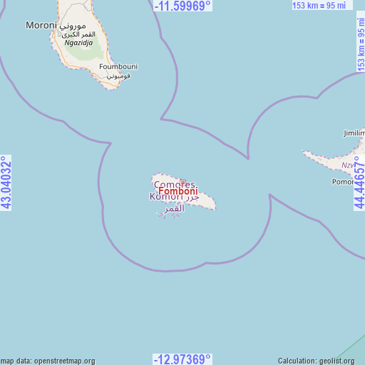
Fomboni GPS coordinates[2]
12° 17' 15.324" South, 43° 44' 36.384" East
| Map corner | latitude | longitude |
|---|---|---|
| Upper-left | -11.59969°, | 43.04032° |
| Center: | -12.28759°, | 43.74344° |
| Lower-right: | -12.97369°, | 44.44657° |
| Map W x H: | 152.8×152.8 km | = 94.9×94.9mi |
| max Lat: | -11.38472° ⇑85.8% North |
| Fomboni: | -12.28759° |
| min Lat: | ⇓14.2% South -12.37306° |
| min Long | Fomboni | max Long |
| 43.2525° | 43.74344° | 44.53194° |
| W 55.8%⇐ | ⇒44.2% E |
Elevation
Elevation of Fomboni is 18 m = 59 ft, and this is 178.1 m = 584 ft below average elevation for this country.
| Max E: |
924 m = 3031 ft | 92.9% |
| Avg. | 196.1 m = 643 ft | |
| Fomboni | 18 m = 59 ft | |
Min E: |
1 m = 3 ft | 7.1% |
See also: Comoros elevation on elevation.city.
Geographical zone
Fomboni is located in South Torrid zone (between Equator and Tropic of Capricorn). Distance of this Southern Tropic circle is 1239.7 km =770.3 mi to South.| Distance of | km | miles | from Fomboni |
|---|---|---|---|
| Equator | 1366.3 | 849 | to North |
| Tropic Capricorn | 1239.7 | 770.3 | to South |
| Antarctic Circle | 6034.9 | 3749.9 | to South |
| South Pole | 8640.8 | 5369.1 | to South |


Nearby cities:
15 places around Fomboni: (largest is in red/bold)
• Chindini
48.9 km =30.4 mi,  325°
325°
• Djoyézi
3.9 km =2.4 mi,  121°
121°
• Foumbouni
54.1 km =33.6 mi, 330°
• Hamavouna
14 km =8.7 mi,  132°
132°
• Hamba
12.2 km =7.6 mi,  276°
276°
• Hoani
8.5 km =5.3 mi,  298°
298°
• Itsamia
16 km =9.9 mi, 122°
• Kangani
10.3 km =6.4 mi, 126°
• Kové
54.5 km =33.9 mi, 327°
• Miringoni
11.8 km =7.3 mi,  265°
265°
• Mtakoudja
5.2 km =3.2 mi, 304°
• Nioumachoua
8.8 km =5.5 mi,  200°
200°
• Ouanani
8.1 km =5 mi, 133°
• Ourovéni
49.4 km =30.7 mi, 327°
• Ziroudani
6.2 km =3.9 mi,  143°
143°
Sources, notices
• [Note1] Compared only with cities in Comoros existing in our database
• [Src1] Map data: © OpenStreetMap contributors (CC-BY-SA)
• [Src2] Other city data from geonames.org with taken over terms of usage.
• [Src3] Geographical zone / Annual Mean Temperature by Robert A. Rohde @ Wikipedia
