Djoyézi geodata
Djoyézi (Mohéli) is a populated place; located in Comoros in Indian/Comoro (GMT+3) time zone. With population of 2,854 people, there are 32 cities with bigger population in this country. Compared to other cities in Comoros, 88.5% of cities are located further ↑North; 56.6% of cities are located further ←West and 93.8% of cities have higher elevation than Djoyézi. Note1


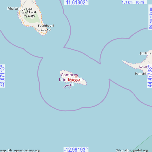
Djoyézi GPS coordinates[2]
12° 18' 21.132" South, 43° 46' 27.3" East
| Map corner | latitude | longitude |
|---|---|---|
| Upper-left | -11.61802°, | 43.07113° |
| Center: | -12.30587°, | 43.77425° |
| Lower-right: | -12.99193°, | 44.47738° |
| Map W x H: | 152.8×152.8 km | = 94.9×94.9mi |
| max Lat: | -11.38472° ⇑88.5% North |
| Djoyézi: | -12.30587° |
| min Lat: | ⇓11.5% South -12.37306° |
| min Long | Djoyézi | max Long |
| 43.2525° | 43.77425° | 44.53194° |
| W 56.6%⇐ | ⇒43.4% E |
Elevation
Elevation of Djoyézi is 15 m = 49 ft, and this is 181.1 m = 594 ft below average elevation for this country.
| Max E: |
924 m = 3031 ft | 93.8% |
| Avg. | 196.1 m = 643 ft | |
| Djoyézi | 15 m = 49 ft | |
Min E: |
1 m = 3 ft | 6.2% |
See also: Comoros elevation on elevation.city.
Geographical zone
Djoyézi is located in South Torrid zone (between Equator and Tropic of Capricorn). Distance of this Southern Tropic circle is 1237.6 km =769 mi to South.| Distance of | km | miles | from Djoyézi |
|---|---|---|---|
| Equator | 1368.3 | 850.2 | to North |
| Tropic Capricorn | 1237.6 | 769 | to South |
| Antarctic Circle | 6032.9 | 3748.7 | to South |
| South Pole | 8638.8 | 5367.9 | to South |


Nearby cities:
15 places around Djoyézi: (largest is in red/bold)
• Bimbini
51.8 km =32.2 mi,  75°
75°
• Chindini
52.5 km =32.6 mi,  324°
324°
• Fomboni
3.9 km =2.4 mi,  301°
301°
• Hamavouna
10.2 km =6.3 mi,  137°
137°
• Hamba
15.9 km =9.9 mi,  282°
282°
• Hoani
12.4 km =7.7 mi, 299°
• Itsamia
12.1 km =7.5 mi,  122°
122°
• Kangani
6.4 km =4 mi,  129°
129°
• Miringoni
15.1 km =9.4 mi,  273°
273°
• Mirongani
53.5 km =33.2 mi, 76°
• Mtakoudja
9.1 km =5.7 mi, 302°
• Nioumachoua
8.9 km =5.5 mi,  226°
226°
• Ouanani
4.3 km =2.7 mi, 144°
• Ourovéni
52.9 km =32.9 mi,  325°
325°
• Ziroudani
3 km =1.9 mi,  173°
173°
Sources, notices
• [Note1] Compared only with cities in Comoros existing in our database
• [Src1] Map data: © OpenStreetMap contributors (CC-BY-SA)
• [Src2] Other city data from geonames.org with taken over terms of usage.
• [Src3] Geographical zone / Annual Mean Temperature by Robert A. Rohde @ Wikipedia
