Assimpao geodata
Assimpao (Anjouan) is a populated place; located in Comoros in Indian/Comoro (GMT+3) time zone. With population of 1,112 people, there are 82 cities with bigger population in this country. Compared to other cities in Comoros, 77% of cities are located further ↑North; 69.9% of cities are located further ←West and 55.8% of cities have higher elevation than Assimpao. Note1


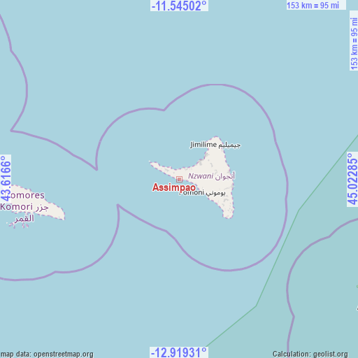
Assimpao GPS coordinates[2]
12° 13' 59.016" South, 44° 19' 10.992" East
| Map corner | latitude | longitude |
|---|---|---|
| Upper-left | -11.54502°, | 43.6166° |
| Center: | -12.23306°, | 44.31972° |
| Lower-right: | -12.91931°, | 45.02285° |
| Map W x H: | 152.8×152.8 km | = 94.9×94.9mi |
| max Lat: | -11.38472° ⇑77% North |
| Assimpao: | -12.23306° |
| min Lat: | ⇓23% South -12.37306° |
| min Long | Assimpao | max Long |
| 43.2525° | 44.31972° | 44.53194° |
| W 69.9%⇐ | ⇒30.1% E |
Elevation
Elevation of Assimpao is 125 m = 410 ft, and this is 71.1 m = 233 ft below average elevation for this country.
| Max E: |
924 m = 3031 ft | 55.8% |
| Avg. | 196.1 m = 643 ft | |
| Assimpao | 125 m = 410 ft | |
Min E: |
1 m = 3 ft | 44.2% |
See also: Comoros elevation on elevation.city.
Geographical zone
Assimpao is located in South Torrid zone (between Equator and Tropic of Capricorn). Distance of this Southern Tropic circle is 1245.7 km =774 mi to South.| Distance of | km | miles | from Assimpao |
|---|---|---|---|
| Equator | 1360.2 | 845.2 | to North |
| Tropic Capricorn | 1245.7 | 774 | to South |
| Antarctic Circle | 6041 | 3753.7 | to South |
| South Pole | 8646.9 | 5372.9 | to South |


Nearby cities:
15 places around Assimpao: (largest is in red/bold)
• Bandajou
5.8 km =3.6 mi,  322°
322°
• Bimbini
10.4 km =6.5 mi,  298°
298°
• Boungouéni
3.8 km =2.4 mi, 324°
• Chironkamba
5.9 km =3.7 mi,  37°
37°
• Chitrouni
5.5 km =3.4 mi,  18°
18°
• Kavani
7.1 km =4.4 mi,  309°
309°
• Maraharé
0.7 km =0.4 mi,  289°
289°
• Milembéni
7.2 km =4.5 mi, 302°
• Mirongani
8.7 km =5.4 mi, 302°
• Mjamaoué
4.5 km =2.8 mi,  346°
346°
• Mjimandra
7.2 km =4.5 mi,  50°
50°
• Pajé
10.2 km =6.3 mi, 46°
• Sima
6.3 km =3.9 mi, 311°
• Vassy
2.5 km =1.6 mi,  87°
87°
• Vouani
6.1 km =3.8 mi,  101°
101°
Sources, notices
• [Note1] Compared only with cities in Comoros existing in our database
• [Src1] Map data: © OpenStreetMap contributors (CC-BY-SA)
• [Src2] Other city data from geonames.org with taken over terms of usage.
• [Src3] Geographical zone / Annual Mean Temperature by Robert A. Rohde @ Wikipedia
