Milembéni geodata
Milembéni (Anjouan) is a populated place; located in Comoros in Indian/Comoro (GMT+3) time zone. With population of 885 people, there are 93 cities with bigger population in this country. Compared to other cities in Comoros, 69.9% of cities are located further ↑North; 63.7% of cities are located further ←West and 65.5% of cities have lower elevation than Milembéni. Note1


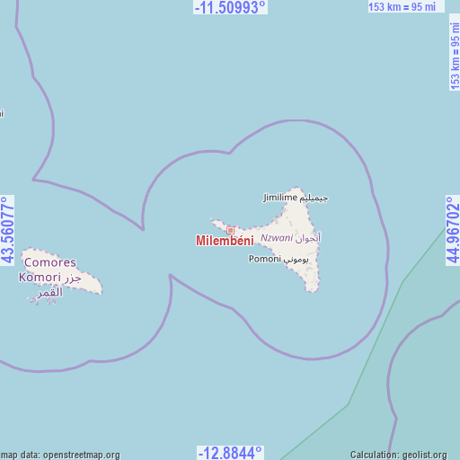
Milembéni GPS coordinates[2]
12° 11' 53.016" South, 44° 15' 50.004" East
| Map corner | latitude | longitude |
|---|---|---|
| Upper-left | -11.50993°, | 43.56077° |
| Center: | -12.19806°, | 44.26389° |
| Lower-right: | -12.8844°, | 44.96702° |
| Map W x H: | 152.8×152.8 km | = 94.9×94.9mi |
| max Lat: | -11.38472° ⇑69.9% North |
| Milembéni: | -12.19806° |
| min Lat: | ⇓30.1% South -12.37306° |
| min Long | Milembéni | max Long |
| 43.2525° | 44.26389° | 44.53194° |
| W 63.7%⇐ | ⇒36.3% E |
Elevation
Elevation of Milembéni is 199 m = 653 ft, and this is 2.9 m = 10 ft above average elevation for this country.
| Max E: |
924 m = 3031 ft | 34.5% |
| Milembéni | 199 m 653 ft | |
| Avg. | 196.1 m = 643 ft | |
Min E: |
1 m = 3 ft | 65.5% |
See also: Comoros elevation on elevation.city.
Geographical zone
Milembéni is located in South Torrid zone (between Equator and Tropic of Capricorn). Distance of this Southern Tropic circle is 1249.6 km =776.5 mi to South.| Distance of | km | miles | from Milembéni |
|---|---|---|---|
| Equator | 1356.3 | 842.8 | to North |
| Tropic Capricorn | 1249.6 | 776.5 | to South |
| Antarctic Circle | 6044.9 | 3756.1 | to South |
| South Pole | 8650.8 | 5375.4 | to South |


Nearby cities:
15 places around Milembéni: (largest is in red/bold)
• Assimpao
7.2 km =4.5 mi,  122°
122°
• Bandajou
2.6 km =1.6 mi,  74°
74°
• Bimbini
3.3 km =2.1 mi,  289°
289°
• Boungouéni
4 km =2.5 mi,  102°
102°
• Chironkamba
9.7 km =6 mi,  85°
85°
• Chitrouni
7.9 km =4.9 mi,  80°
80°
• Kavani
0.9 km =0.6 mi,  41°
41°
• Maraharé
6.5 km =4 mi, 124°
• Mirongani
1.5 km =0.9 mi,  303°
303°
• Mjamaoué
5 km =3.1 mi, 84°
• Mjimandra
11.6 km =7.2 mi, 86°
• Pajé
13.9 km =8.6 mi, 76°
• Sima
1.4 km =0.9 mi, 78°
• Vassy
9.3 km =5.8 mi,  113°
113°
• Vouani
13.1 km =8.1 mi, 113°
Sources, notices
• [Note1] Compared only with cities in Comoros existing in our database
• [Src1] Map data: © OpenStreetMap contributors (CC-BY-SA)
• [Src2] Other city data from geonames.org with taken over terms of usage.
• [Src3] Geographical zone / Annual Mean Temperature by Robert A. Rohde @ Wikipedia
