Chitrouni geodata
Chitrouni (Anjouan) is a populated place; located in Comoros in Indian/Comoro (GMT+3) time zone. With population of 1,081 people, there are 84 cities with bigger population in this country. Compared to other cities in Comoros, 61.1% of cities are located further ↑North; 70.8% of cities are located further ←West and 80.5% of cities have higher elevation than Chitrouni. Note1


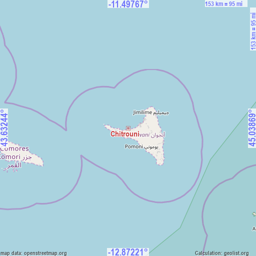
Chitrouni GPS coordinates[2]
12° 11' 8.988" South, 44° 20' 8.016" East
| Map corner | latitude | longitude |
|---|---|---|
| Upper-left | -11.49767°, | 43.63244° |
| Center: | -12.18583°, | 44.33556° |
| Lower-right: | -12.87221°, | 45.03869° |
| Map W x H: | 152.8×152.8 km | = 94.9×94.9mi |
| max Lat: | -11.38472° ⇑61.1% North |
| Chitrouni: | -12.18583° |
| min Lat: | ⇓38.9% South -12.37306° |
| min Long | Chitrouni | max Long |
| 43.2525° | 44.33556° | 44.53194° |
| W 70.8%⇐ | ⇒29.2% E |
Elevation
Elevation of Chitrouni is 39 m = 128 ft, and this is 157.1 m = 515 ft below average elevation for this country.
| Max E: |
924 m = 3031 ft | 80.5% |
| Avg. | 196.1 m = 643 ft | |
| Chitrouni | 39 m = 128 ft | |
Min E: |
1 m = 3 ft | 19.5% |
See also: Comoros elevation on elevation.city.
Geographical zone
Chitrouni is located in South Torrid zone (between Equator and Tropic of Capricorn). Distance of this Southern Tropic circle is 1251 km =777.3 mi to South.| Distance of | km | miles | from Chitrouni |
|---|---|---|---|
| Equator | 1354.9 | 841.9 | to North |
| Tropic Capricorn | 1251 | 777.3 | to South |
| Antarctic Circle | 6046.2 | 3756.9 | to South |
| South Pole | 8652.1 | 5376.2 | to South |


Nearby cities:
15 places around Chitrouni: (largest is in red/bold)
• Assimpao
5.5 km =3.4 mi,  198°
198°
• Bandajou
5.3 km =3.3 mi,  262°
262°
• Boungouéni
4.5 km =2.8 mi,  240°
240°
• Chironkamba
1.9 km =1.2 mi,  107°
107°
• Kavani
7.2 km =4.5 mi, 264°
• Maraharé
5.6 km =3.5 mi,  205°
205°
• Milembéni
7.9 km =4.9 mi, 260°
• Mirontsi
8.5 km =5.3 mi,  67°
67°
• Mjamaoué
2.9 km =1.8 mi,  252°
252°
• Mjimandra
3.8 km =2.4 mi,  99°
99°
• Moutsamoudou
7.3 km =4.5 mi, 72°
• Pajé
6 km =3.7 mi, 72°
• Sima
6.5 km =4 mi, 260°
• Vassy
5.2 km =3.2 mi,  171°
171°
• Vouani
7.7 km =4.8 mi,  146°
146°
Sources, notices
• [Note1] Compared only with cities in Comoros existing in our database
• [Src1] Map data: © OpenStreetMap contributors (CC-BY-SA)
• [Src2] Other city data from geonames.org with taken over terms of usage.
• [Src3] Geographical zone / Annual Mean Temperature by Robert A. Rohde @ Wikipedia
