Vassy geodata
Vassy (Anjouan) is a populated place; located in Comoros in Indian/Comoro (GMT+3) time zone. With population of 944 people, there are 91 cities with bigger population in this country. Compared to other cities in Comoros, 76.1% of cities are located further ↑North; 71.7% of cities are located further ←West and 59.3% of cities have higher elevation than Vassy. Note1


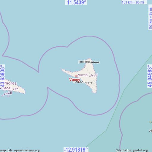
Vassy GPS coordinates[2]
12° 13' 54.984" South, 44° 20' 33" East
| Map corner | latitude | longitude |
|---|---|---|
| Upper-left | -11.5439°, | 43.63938° |
| Center: | -12.23194°, | 44.3425° |
| Lower-right: | -12.91819°, | 45.04563° |
| Map W x H: | 152.8×152.8 km | = 94.9×94.9mi |
| max Lat: | -11.38472° ⇑76.1% North |
| Vassy: | -12.23194° |
| min Lat: | ⇓23.9% South -12.37306° |
| min Long | Vassy | max Long |
| 43.2525° | 44.3425° | 44.53194° |
| W 71.7%⇐ | ⇒28.3% E |
Elevation
Elevation of Vassy is 97 m = 318 ft, and this is 99.1 m = 325 ft below average elevation for this country.
| Max E: |
924 m = 3031 ft | 59.3% |
| Avg. | 196.1 m = 643 ft | |
| Vassy | 97 m = 318 ft | |
Min E: |
1 m = 3 ft | 40.7% |
See also: Comoros elevation on elevation.city.
Geographical zone
Vassy is located in South Torrid zone (between Equator and Tropic of Capricorn). Distance of this Southern Tropic circle is 1245.9 km =774.2 mi to South.| Distance of | km | miles | from Vassy |
|---|---|---|---|
| Equator | 1360.1 | 845.1 | to North |
| Tropic Capricorn | 1245.9 | 774.2 | to South |
| Antarctic Circle | 6041.1 | 3753.8 | to South |
| South Pole | 8647 | 5373 | to South |


Nearby cities:
15 places around Vassy: (largest is in red/bold)
• Assimpao
2.5 km =1.6 mi,  267°
267°
• Bandajou
7.5 km =4.7 mi,  306°
306°
• Boungouéni
5.5 km =3.4 mi,  302°
302°
• Chironkamba
4.7 km =2.9 mi,  13°
13°
• Chitrouni
5.2 km =3.2 mi,  351°
351°
• Kavani
9.1 km =5.7 mi, 299°
• Lingoni
8.7 km =5.4 mi,  107°
107°
• Maraharé
3.2 km =2 mi, 272°
• Milembéni
9.3 km =5.8 mi,  293°
293°
• Mjamaoué
5.5 km =3.4 mi,  320°
320°
• Mjimandra
5.4 km =3.4 mi,  33°
33°
• Moutsamoudou
9.5 km =5.9 mi,  40°
40°
• Pajé
8.5 km =5.3 mi, 35°
• Sima
8.2 km =5.1 mi, 299°
• Vouani
3.7 km =2.3 mi, 111°
Sources, notices
• [Note1] Compared only with cities in Comoros existing in our database
• [Src1] Map data: © OpenStreetMap contributors (CC-BY-SA)
• [Src2] Other city data from geonames.org with taken over terms of usage.
• [Src3] Geographical zone / Annual Mean Temperature by Robert A. Rohde @ Wikipedia
