Batsa geodata
Batsa (Grande Comore) is a populated place; located in Comoros in Indian/Comoro (GMT+3) time zone. With population of 692 people, there are 105 cities with bigger population in this country. Compared to other cities in Comoros, 78.8% of cities are located further ↓South; 96.5% of cities are located further →East and 61.1% of cities have lower elevation than Batsa. Note1


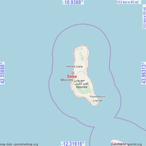
Batsa GPS coordinates[2]
11° 37' 41.988" South, 43° 15' 36" East
| Map corner | latitude | longitude |
|---|---|---|
| Upper-left | -10.9388°, | 42.55688° |
| Center: | -11.62833°, | 43.26° |
| Lower-right: | -12.31616°, | 43.96313° |
| Map W x H: | 153.1×153.2 km | = 95.1×95.2mi |
| max Lat: | -11.38472° ⇑21.2% North |
| Batsa: | -11.62833° |
| min Lat: | ⇓78.8% South -12.37306° |
| min Long | Batsa | max Long |
| 43.2525° | 43.26° | 44.53194° |
| W 3.5%⇐ | ⇒96.5% E |
Elevation
Elevation of Batsa is 168 m = 551 ft, and this is 28.1 m = 92 ft below average elevation for this country.
| Max E: |
924 m = 3031 ft | 38.9% |
| Avg. | 196.1 m = 643 ft | |
| Batsa | 168 m = 551 ft | |
Min E: |
1 m = 3 ft | 61.1% |
See also: Comoros elevation on elevation.city.
Geographical zone
Batsa is located in South Torrid zone (between Equator and Tropic of Capricorn). Distance of Equator is 1292.9 km =803.4 mi to North.| Distance of | km | miles | from Batsa |
|---|---|---|---|
| Equator | 1292.9 | 803.4 | to North |
| Tropic Capricorn | 1313 | 815.9 | to South |
| Antarctic Circle | 6108.2 | 3795.5 | to South |
| South Pole | 8714.1 | 5414.7 | to South |


Nearby cities:
15 places around Batsa: (largest is in red/bold)
• Bahani
2.9 km =1.8 mi,  115°
115°
• Bibavou
6.5 km =4 mi,  16°
16°
• Dzahani
3.6 km =2.2 mi,  152°
152°
• Itsandra
4.8 km =3 mi,  186°
186°
• Milembéni
3.8 km =2.4 mi,  169°
169°
• Milévani
9.2 km =5.7 mi, 21°
• Moroni
8.2 km =5.1 mi,  183°
183°
• Mvouni
9.8 km =6.1 mi, 176°
• Ntsoudjini
3.5 km =2.2 mi, 177°
• Oussivo
4.9 km =3 mi,  9°
9°
• Tsidjé
7.8 km =4.8 mi, 178°
• Vanadjou
2.9 km =1.8 mi,  37°
37°
• Vanambouani
2 km =1.2 mi,  338°
338°
• Wela
3.6 km =2.2 mi,  141°
141°
• Zivandani
2 km =1.2 mi,  161°
161°
Sources, notices
• [Note1] Compared only with cities in Comoros existing in our database
• [Src1] Map data: © OpenStreetMap contributors (CC-BY-SA)
• [Src2] Other city data from geonames.org with taken over terms of usage.
• [Src3] Geographical zone / Annual Mean Temperature by Robert A. Rohde @ Wikipedia
