Hoeryŏng geodata
Hoeryŏng (Hamgyŏng-bukto) is a seat of a second-order administrative division; located in North Korea in Asia/Pyongyang (GMT+9) time zone. With population of 43,831 people, there are 25 cities with bigger population in this country. Compared to other cities in North Korea, 86.8% of cities are located further ↓South; 81.3% of cities are located further ←West and 81.3% of cities have lower elevation than Hoeryŏng. Note1


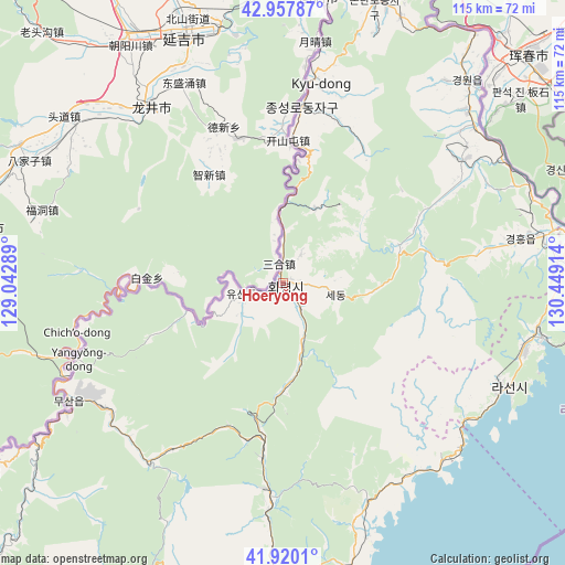
Hoeryŏng GPS coordinates[2]
42° 26' 28.068" North, 129° 44' 45.636" East
| Map corner | latitude | longitude |
|---|---|---|
| Upper-left | 42.95787°, | 129.04289° |
| Center: | 42.44113°, | 129.74601° |
| Lower-right: | 41.9201°, | 130.44914° |
| Map W x H: | 115.4×115.4 km | = 71.7×71.7mi |
| max Lat: | 42.95722° ⇑13.2% North |
| Hoeryŏng: | 42.44113° |
| min Lat: | ⇓86.8% South 37.90889° |
| min Long | Hoeryŏng | max Long |
| 124.39806° | 129.74601° | 130.49522° |
| W 81.3%⇐ | ⇒18.7% E |
Elevation
Elevation of Hoeryŏng is 217 m = 712 ft, and this is 85.3 m = 280 ft above average elevation for this country.
| Max E: |
1466 m = 4810 ft | 18.7% |
| Hoeryŏng | 217 m 712 ft | |
| Avg. | 131.7 m = 432 ft | |
Min E: |
1 m = 3 ft | 81.3% |
See also: Hoeryŏng elevation on elevation.city.
Geographical zone
Hoeryŏng is located in North temperate zone (between Tropic of Cancer and the Arctic Circle). Distance of this Northern Tropic circle is 2113.1 km =1313 mi to South.| Distance of | km | miles | from Hoeryŏng |
|---|---|---|---|
| North Pole | 5288.1 | 3285.9 | to North |
| Arctic Circle | 2682.2 | 1666.6 | to North |
| Tropic Cancer | 2113.1 | 1313 | to South |
| Equator | 4719 | 2932.2 | to South |


Nearby cities:
15 places around Hoeryŏng: (largest is in red/bold)
• Chungbong
18.9 km =11.7 mi,  36°
36°
• Kogŏnwon
44.8 km =27.8 mi,  56°
56°
• Komusan Il-tong
37.1 km =23.1 mi,  185°
185°
• Kwirak
47.5 km =29.5 mi,  82°
82°
• Kyŏngwŏn
53.1 km =33 mi, 38°
• Musan-ŭp
50.3 km =31.3 mi,  241°
241°
• Namsan
46.9 km =29.1 mi, 239°
• Puryŏng
42.4 km =26.3 mi,  183°
183°
• Rajin
48.7 km =30.3 mi,  115°
115°
• Ryongdang
50.4 km =31.3 mi,  51°
51°
• Sambong
27.8 km =17.3 mi,  8°
8°
• Sech’ŏn
16.9 km =10.5 mi,  26°
26°
• Sŏnbong
53.3 km =33.1 mi,  100°
100°
• Sŏng-dong
10.2 km =6.3 mi, 238°
• Ŭndŏk
49 km =30.4 mi, 79°
Sources, notices
• [Note1] Compared only with cities in North Korea existing in our database
• [Src1] Map data: © OpenStreetMap contributors (CC-BY-SA)
• [Src2] Other city data from geonames.org with taken over terms of usage.
• [Src3] Geographical zone / Annual Mean Temperature by Robert A. Rohde @ Wikipedia
