Sŏng-dong geodata
Sŏng-dong (Hamgyŏng-bukto) is a seat of a third-order administrative division; located in North Korea in Asia/Pyongyang (GMT+9) time zone. In our database, there are 78 cities with bigger population. Compared to other cities in North Korea, 85.7% of cities are located further ↓South; 74.7% of cities are located further ←West and 89% of cities have lower elevation than Sŏng-dong. Note1


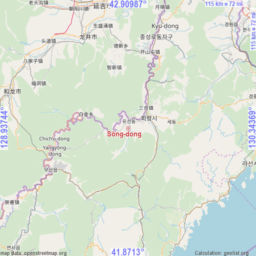
Sŏng-dong GPS coordinates[2]
42° 23' 33.828" North, 129° 38' 26.016" East
| Map corner | latitude | longitude |
|---|---|---|
| Upper-left | 42.90987°, | 128.93744° |
| Center: | 42.39273°, | 129.64056° |
| Lower-right: | 41.8713°, | 130.34369° |
| Map W x H: | 115.5×115.5 km | = 71.8×71.8mi |
| max Lat: | 42.95722° ⇑14.3% North |
| Sŏng-dong: | 42.39273° |
| min Lat: | ⇓85.7% South 37.90889° |
| min Long | Sŏng-dong | max Long |
| 124.39806° | 129.64056° | 130.49522° |
| W 74.7%⇐ | ⇒25.3% E |
Elevation
Elevation of Sŏng-dong is 326 m = 1070 ft, and this is 194.3 m = 637 ft above average elevation for this country.
| Max E: |
1466 m = 4810 ft | 11% |
| Sŏng-dong | 326 m 1070 ft | |
| Avg. | 131.7 m = 432 ft | |
Min E: |
1 m = 3 ft | 89% |
See also: North Korea elevation on elevation.city.
Geographical zone
Sŏng-dong is located in North temperate zone (between Tropic of Cancer and the Arctic Circle). Distance of this Northern Tropic circle is 2107.7 km =1309.7 mi to South.| Distance of | km | miles | from Sŏng-dong |
|---|---|---|---|
| North Pole | 5293.4 | 3289.2 | to North |
| Arctic Circle | 2687.5 | 1669.9 | to North |
| Tropic Cancer | 2107.7 | 1309.7 | to South |
| Equator | 4713.6 | 2928.9 | to South |


Nearby cities:
15 places around Sŏng-dong: (largest is in red/bold)
• Chungbong
28.7 km =17.8 mi,  44°
44°
• Hoeryŏng
10.2 km =6.3 mi,  58°
58°
• Kogŏnwon
54.9 km =34.1 mi, 56°
• Komusan Il-tong
31.9 km =19.8 mi,  171°
171°
• Kwirak
56.9 km =35.4 mi,  78°
78°
• Kyŏngwŏn
62.8 km =39 mi, 41°
• Musan-ŭp
40.1 km =24.9 mi,  242°
242°
• Namsan
36.7 km =22.8 mi, 239°
• Puryŏng
37.4 km =23.2 mi, 170°
• Rajin
55 km =34.2 mi,  106°
106°
• Ryongdang
60.5 km =37.6 mi,  52°
52°
• Sambong
35.2 km =21.9 mi,  20°
20°
• Sech’ŏn
26.1 km =16.2 mi, 38°
• Sŏnbong
61.2 km =38 mi,  94°
94°
• Ŭndŏk
58.7 km =36.5 mi, 76°
Sources, notices
• [Note1] Compared only with cities in North Korea existing in our database
• [Src1] Map data: © OpenStreetMap contributors (CC-BY-SA)
• [Src2] Other city data from geonames.org with taken over terms of usage.
• [Src3] Geographical zone / Annual Mean Temperature by Robert A. Rohde @ Wikipedia
