Puryŏng geodata
Puryŏng (Hamgyŏng-bukto) is a populated place; located in North Korea in Asia/Pyongyang (GMT+9) time zone. With population of 12,267 people, there are 67 cities with bigger population in this country. Compared to other cities in North Korea, 76.9% of cities are located further ↓South; 80.2% of cities are located further ←West and 75.8% of cities have lower elevation than Puryŏng. Note1


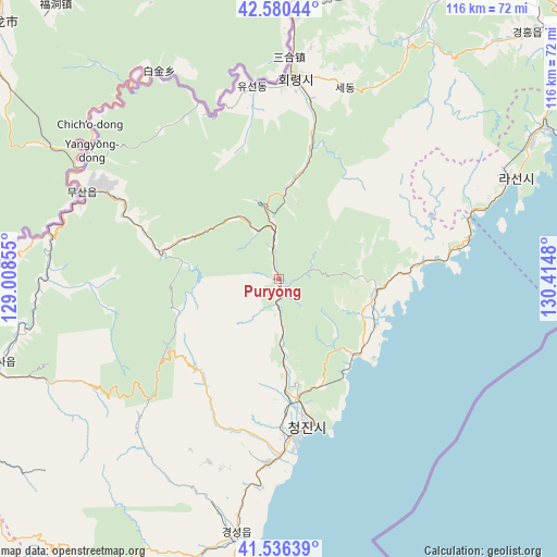
Puryŏng GPS coordinates[2]
42° 3' 38.016" North, 129° 42' 42.012" East
| Map corner | latitude | longitude |
|---|---|---|
| Upper-left | 42.58044°, | 129.00855° |
| Center: | 42.06056°, | 129.71167° |
| Lower-right: | 41.53639°, | 130.4148° |
| Map W x H: | 116.1×116.1 km | = 72.1×72.1mi |
| max Lat: | 42.95722° ⇑23.1% North |
| Puryŏng: | 42.06056° |
| min Lat: | ⇓76.9% South 37.90889° |
| min Long | Puryŏng | max Long |
| 124.39806° | 129.71167° | 130.49522° |
| W 80.2%⇐ | ⇒19.8% E |
Elevation
Elevation of Puryŏng is 168 m = 551 ft, and this is 36.3 m = 119 ft above average elevation for this country.
| Max E: |
1466 m = 4810 ft | 24.2% |
| Puryŏng | 168 m 551 ft | |
| Avg. | 131.7 m = 432 ft | |
Min E: |
1 m = 3 ft | 75.8% |
See also: North Korea elevation on elevation.city.
Geographical zone
Puryŏng is located in North temperate zone (between Tropic of Cancer and the Arctic Circle). Distance of this Northern Tropic circle is 2070.8 km =1286.7 mi to South.| Distance of | km | miles | from Puryŏng |
|---|---|---|---|
| North Pole | 5330.4 | 3312.2 | to North |
| Arctic Circle | 2724.5 | 1692.9 | to North |
| Tropic Cancer | 2070.8 | 1286.7 | to South |
| Equator | 4676.7 | 2906 | to South |


Nearby cities:
15 places around Puryŏng: (largest is in red/bold)
• Chongjin
29.9 km =18.6 mi,  169°
169°
• Chungbong
59.2 km =36.8 mi,  13°
13°
• Hoemul-li
69.8 km =43.4 mi,  182°
182°
• Hoeryŏng
42.4 km =26.3 mi,  3°
3°
• Komusan Il-tong
5.5 km =3.4 mi,  349°
349°
• Kwirak
69.5 km =43.2 mi,  46°
46°
• Kyŏngsŏng
53.3 km =33.1 mi,  189°
189°
• Musan-ŭp
45.4 km =28.2 mi,  293°
293°
• Namsan
42 km =26.1 mi,  296°
296°
• Nanam
38.6 km =24 mi, 183°
• Rajin
51.9 km =32.2 mi,  65°
65°
• Sech’ŏn
58.4 km =36.3 mi, 10°
• Sŏnbong
64 km =39.8 mi,  59°
59°
• Sŏng-dong
37.4 km =23.2 mi, 350°
• Sŭngam-nodongjagu
43.6 km =27.1 mi, 184°
Sources, notices
• [Note1] Compared only with cities in North Korea existing in our database
• [Src1] Map data: © OpenStreetMap contributors (CC-BY-SA)
• [Src2] Other city data from geonames.org with taken over terms of usage.
• [Src3] Geographical zone / Annual Mean Temperature by Robert A. Rohde @ Wikipedia
