Aoji geodata
Aoji (Hamgyŏng-bukto) is a populated place; located in North Korea in Asia/Pyongyang (GMT+9) time zone. With population of 34,248 people, there are 31 cities with bigger population in this country. Compared to other cities in North Korea, 91.2% of cities are located further ↓South; 96.7% of cities are located further ←West and 58.2% of cities have higher elevation than Aoji. Note1


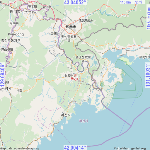
Aoji GPS coordinates[2]
42° 31' 28.128" North, 130° 23' 49.848" East
| Map corner | latitude | longitude |
|---|---|---|
| Upper-left | 43.04052°, | 129.69406° |
| Center: | 42.52448°, | 130.39718° |
| Lower-right: | 42.00414°, | 131.10031° |
| Map W x H: | 115.2×115.2 km | = 71.6×71.6mi |
| max Lat: | 42.95722° ⇑8.8% North |
| Aoji: | 42.52448° |
| min Lat: | ⇓91.2% South 37.90889° |
| min Long | Aoji | max Long |
| 124.39806° | 130.39718° | 130.49522° |
| W 96.7%⇐ | ⇒3.3% E |
Elevation
Elevation of Aoji is 30 m = 98 ft, and this is 101.7 m = 334 ft below average elevation for this country.
| Max E: |
1466 m = 4810 ft | 58.2% |
| Avg. | 131.7 m = 432 ft | |
| Aoji | 30 m = 98 ft | |
Min E: |
1 m = 3 ft | 41.8% |
See also: North Korea elevation on elevation.city.
Geographical zone
Aoji is located in North temperate zone (between Tropic of Cancer and the Arctic Circle). Distance of this Northern Tropic circle is 2122.4 km =1318.8 mi to South.| Distance of | km | miles | from Aoji |
|---|---|---|---|
| North Pole | 5278.8 | 3280.1 | to North |
| Arctic Circle | 2672.9 | 1660.9 | to North |
| Tropic Cancer | 2122.4 | 1318.8 | to South |
| Equator | 4728.3 | 2938 | to South |


Nearby cities:
15 places around Aoji: (largest is in red/bold)
• Chungbong
42.4 km =26.3 mi,  278°
278°
• Hahoe-dong
8.3 km =5.2 mi,  105°
105°
• Hoeryŏng
54.2 km =33.7 mi,  260°
260°
• Kogŏnwon
22.2 km =13.8 mi,  313°
313°
• Kwirak
7.2 km =4.5 mi,  241°
241°
• Kyŏngwŏn
37.9 km =23.5 mi,  328°
328°
• Onsŏng
58.3 km =36.2 mi, 325°
• Rajin
31.3 km =19.4 mi,  197°
197°
• Ryongdang
26.2 km =16.3 mi, 327°
• Sambong
52.6 km =32.7 mi,  290°
290°
• Sech’ŏn
46.3 km =28.8 mi, 277°
• Sŏnbong
19.3 km =12 mi,  183°
183°
• Ungsang
20.6 km =12.8 mi,  158°
158°
• Ungsang-nodongjagu
19.3 km =12 mi, 163°
• Ŭndŏk
5.2 km =3.2 mi, 262°
Sources, notices
• [Note1] Compared only with cities in North Korea existing in our database
• [Src1] Map data: © OpenStreetMap contributors (CC-BY-SA)
• [Src2] Other city data from geonames.org with taken over terms of usage.
• [Src3] Geographical zone / Annual Mean Temperature by Robert A. Rohde @ Wikipedia
