Gongju geodata
Gongju (Chungcheongnam-do) is a populated place; located in South Korea in Asia/Seoul (GMT+9) time zone. With population of 72,435 people, there are 67 cities with bigger population in this country. Compared to other cities in South Korea, 67.1% of cities are located further ↓South; 59.1% of cities are located further →East and 67.5% of cities have higher elevation than Gongju. Note1


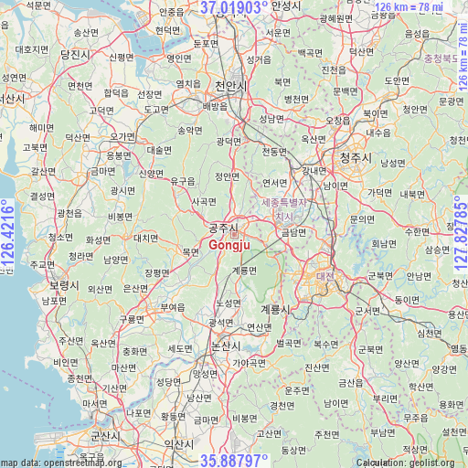
Gongju GPS coordinates[2]
36° 27' 20.016" North, 127° 7' 28.992" East
| Map corner | latitude | longitude |
|---|---|---|
| Upper-left | 37.01903°, | 126.4216° |
| Center: | 36.45556°, | 127.12472° |
| Lower-right: | 35.88797°, | 127.82785° |
| Map W x H: | 125.8×125.8 km | = 78.2×78.2mi |
| max Lat: | 38.37881° ⇑32.9% North |
| Gongju: | 36.45556° |
| min Lat: | ⇓67.1% South 33.25333° |
| min Long | Gongju | max Long |
| 126.10863° | 127.12472° | 129.55377° |
| W 40.9%⇐ | ⇒59.1% E |
Elevation
Elevation of Gongju is 23 m = 75 ft, and this is 47.4 m = 156 ft below average elevation for this country.
| Max E: |
691 m = 2267 ft | 67.5% |
| Avg. | 70.4 m = 231 ft | |
| Gongju | 23 m = 75 ft | |
Min E: |
1 m = 3 ft | 32.5% |
See also: Gongju elevation on elevation.city.
Geographical zone
Gongju is located in North temperate zone (between Tropic of Cancer and the Arctic Circle). Distance of this Northern Tropic circle is 1447.6 km =899.5 mi to South.| Distance of | km | miles | from Gongju |
|---|---|---|---|
| North Pole | 5953.6 | 3699.4 | to North |
| Arctic Circle | 3347.7 | 2080.2 | to North |
| Tropic Cancer | 1447.6 | 899.5 | to South |
| Equator | 4053.5 | 2518.7 | to South |


Nearby cities:
15 places around Gongju: (largest is in red/bold)
• Buyeo
27.9 km =17.3 mi,  223°
223°
• Cheongnam
19.2 km =11.9 mi,  233°
233°
• Cheongyang
28.7 km =17.8 mi,  269°
269°
• Daejeon
26.1 km =16.2 mi,  116°
116°
• Gyuam
29.4 km =18.3 mi, 227°
• Jangpyeong
24.3 km =15.1 mi,  238°
238°
• Jinjam
24.4 km =15.2 mi,  135°
135°
• Nonsan
28.2 km =17.5 mi,  187°
187°
• Sangwol
17.9 km =11.1 mi,  175°
175°
• Sejong
21.3 km =13.2 mi,  44°
44°
• Sintansin
27.4 km =17 mi,  90°
90°
• Songgangdong
22.6 km =14 mi,  96°
96°
• Yesan
35.3 km =21.9 mi,  314°
314°
• Yuseong
22.1 km =13.7 mi, 120°
• Yŏnmu
36.3 km =22.6 mi, 183°
Sources, notices
• [Note1] Compared only with cities in South Korea existing in our database
• [Src1] Map data: © OpenStreetMap contributors (CC-BY-SA)
• [Src2] Other city data from geonames.org with taken over terms of usage.
• [Src3] Geographical zone / Annual Mean Temperature by Robert A. Rohde @ Wikipedia
