Sejong geodata
Sejong (Sejong-si) is a seat of a first-order administrative division; located in South Korea in Asia/Seoul (GMT+9) time zone. With population of 230,327 people, there are 32 cities with bigger population in this country. Compared to other cities in South Korea, 67.8% of cities are located further ↓South; 51.7% of cities are located further ←West and 55.9% of cities have lower elevation than Sejong. Note1


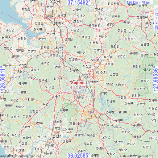
Sejong GPS coordinates[2]
36° 35' 32.82" North, 127° 17' 32.028" East
| Map corner | latitude | longitude |
|---|---|---|
| Upper-left | 37.15492°, | 126.58911° |
| Center: | 36.59245°, | 127.29223° |
| Lower-right: | 36.02585°, | 127.99536° |
| Map W x H: | 125.5×125.5 km | = 78×78mi |
| max Lat: | 38.37881° ⇑32.2% North |
| Sejong: | 36.59245° |
| min Lat: | ⇓67.8% South 33.25333° |
| min Long | Sejong | max Long |
| 126.10863° | 127.29223° | 129.55377° |
| W 51.7%⇐ | ⇒48.3% E |
Elevation
Elevation of Sejong is 49 m = 161 ft, and this is 21.4 m = 70 ft below average elevation for this country.
| Max E: |
691 m = 2267 ft | 44.1% |
| Avg. | 70.4 m = 231 ft | |
| Sejong | 49 m = 161 ft | |
Min E: |
1 m = 3 ft | 55.9% |
See also: Sejong elevation on elevation.city.
Geographical zone
Sejong is located in North temperate zone (between Tropic of Cancer and the Arctic Circle). Distance of this Northern Tropic circle is 1462.8 km =908.9 mi to South.| Distance of | km | miles | from Sejong |
|---|---|---|---|
| North Pole | 5938.4 | 3689.9 | to North |
| Arctic Circle | 3332.5 | 2070.7 | to North |
| Tropic Cancer | 1462.8 | 908.9 | to South |
| Equator | 4068.7 | 2528.2 | to South |


Nearby cities:
15 places around Sejong: (largest is in red/bold)
• Annae
39.6 km =24.6 mi,  123°
123°
• Asan
33.3 km =20.7 mi,  309°
309°
• Cheonan
26.9 km =16.7 mi,  332°
332°
• Cheongju-si
18.3 km =11.4 mi,  74°
74°
• Chinch'ŏn
32.3 km =20.1 mi,  24°
24°
• Daejeon
28.3 km =17.6 mi,  162°
162°
• Gongju
21.3 km =13.2 mi,  224°
224°
• Gunbuk
36.3 km =22.6 mi,  143°
143°
• Hoenam
30.6 km =19 mi, 122°
• Jinjam
32.6 km =20.3 mi,  176°
176°
• Sangwol
35.8 km =22.2 mi,  202°
202°
• Seonghwan
38.7 km =24 mi,  338°
338°
• Sintansin
19.8 km =12.3 mi, 141°
• Songgangdong
19.2 km =11.9 mi, 157°
• Yuseong
26.8 km =16.7 mi,  171°
171°
Sources, notices
• [Note1] Compared only with cities in South Korea existing in our database
• [Src1] Map data: © OpenStreetMap contributors (CC-BY-SA)
• [Src2] Other city data from geonames.org with taken over terms of usage.
• [Src3] Geographical zone / Annual Mean Temperature by Robert A. Rohde @ Wikipedia
