Gimcheon geodata
Gimcheon (Gyeongsangbuk-do) is a populated place; located in South Korea in Asia/Seoul (GMT+9) time zone. With population of 150,000 people, there are 41 cities with bigger population in this country. Compared to other cities in South Korea, 52.8% of cities are located further ↓South; 80.1% of cities are located further ←West and 70.6% of cities have lower elevation than Gimcheon. Note1


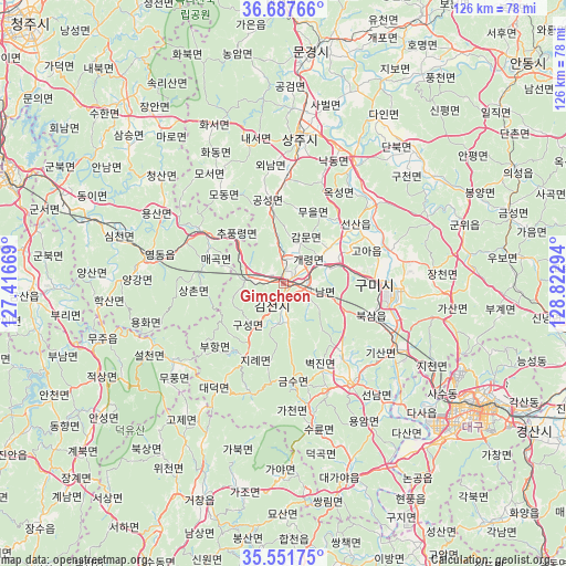
Gimcheon GPS coordinates[2]
36° 7' 18.336" North, 128° 7' 11.316" East
| Map corner | latitude | longitude |
|---|---|---|
| Upper-left | 36.68766°, | 127.41669° |
| Center: | 36.12176°, | 128.11981° |
| Lower-right: | 35.55175°, | 128.82294° |
| Map W x H: | 126.3×126.3 km | = 78.5×78.5mi |
| max Lat: | 38.37881° ⇑47.2% North |
| Gimcheon: | 36.12176° |
| min Lat: | ⇓52.8% South 33.25333° |
| min Long | Gimcheon | max Long |
| 126.10863° | 128.11981° | 129.55377° |
| W 80.1%⇐ | ⇒19.9% E |
Elevation
Elevation of Gimcheon is 81 m = 266 ft, and this is 10.6 m = 35 ft above average elevation for this country.
| Max E: |
691 m = 2267 ft | 29.4% |
| Gimcheon | 81 m 266 ft | |
| Avg. | 70.4 m = 231 ft | |
Min E: |
1 m = 3 ft | 70.6% |
See also: Gimcheon elevation on elevation.city.
Geographical zone
Gimcheon is located in North temperate zone (between Tropic of Cancer and the Arctic Circle). Distance of this Northern Tropic circle is 1410.4 km =876.4 mi to South.| Distance of | km | miles | from Gimcheon |
|---|---|---|---|
| North Pole | 5990.7 | 3722.4 | to North |
| Arctic Circle | 3384.8 | 2103.2 | to North |
| Tropic Cancer | 1410.4 | 876.4 | to South |
| Equator | 4016.4 | 2495.7 | to South |


Nearby cities:
15 places around Gimcheon: (largest is in red/bold)
• Cheongsan
38.5 km =23.9 mi,  310°
310°
• Cheongseong
39.6 km =24.6 mi, 305°
• Chupungnyeong
15.6 km =9.7 mi, 312°
• Gumi
19.4 km =12.1 mi,  92°
92°
• Hwanam
41.1 km =25.5 mi,  332°
332°
• Hwanggan
22.6 km =14 mi,  302°
302°
• Iwon
47 km =29.2 mi,  287°
287°
• Jenzan
20.7 km =12.9 mi,  50°
50°
• Kunwi
42.6 km =26.5 mi,  72°
72°
• Samseung
46.3 km =28.8 mi, 311°
• Sangju
32.8 km =20.4 mi,  6°
6°
• Simcheon
37.9 km =23.5 mi, 289°
• Waegwan
28.8 km =17.9 mi,  119°
119°
• Yeongdong
31.4 km =19.5 mi,  280°
280°
• Yongsan
30.3 km =18.8 mi, 300°
Sources, notices
• [Note1] Compared only with cities in South Korea existing in our database
• [Src1] Map data: © OpenStreetMap contributors (CC-BY-SA)
• [Src2] Other city data from geonames.org with taken over terms of usage.
• [Src3] Geographical zone / Annual Mean Temperature by Robert A. Rohde @ Wikipedia
